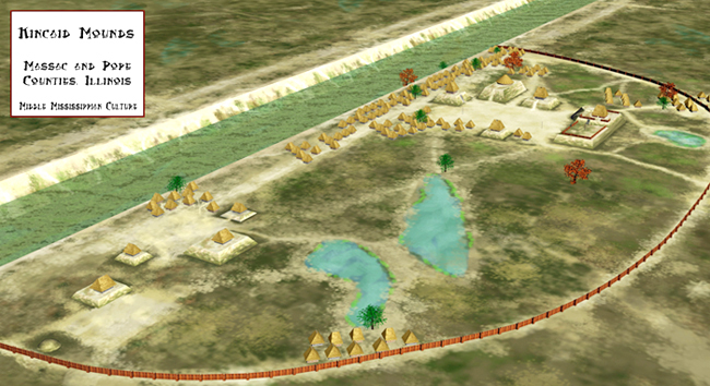
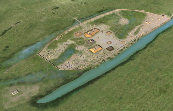
Kincaid Mounds is a Mississippian archaeological site on the floodplain of the Ohio River at the southern tip of Illinois, occupied from about 1050 to 1400 CE. It was the capital of a chiefdom that raised at least eleven substructure platform mounds and eight other monuments around a levelled central plaza — a town large enough to rank fifth among all known Mississippian sites for the number of mounds built there. Kincaid matters twice over: once for what its builders achieved, and once for what happened after 1934, when a University of Chicago field school on these mounds invented much of the method that American archaeology still runs on.
Where Kincaid Mounds Stands on the Lower Ohio
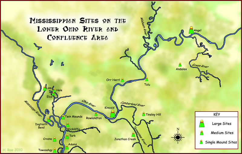
The site sits in the Ohio River bottomlands of deep southern Illinois, straddling the line between Massac and Pope counties in the region locals call Little Egypt. It carries the archaeological site numbers 11MX2-11 and 11PO2-10. The state-owned portion — roughly 105 acres containing the remains of nine mounds and a large slice of the associated village — lies in Massac County; the mounds and village remnants extending north and east are on private farmland in Pope County, and level parts of the site are still planted in crops.
Geography explains the town. Kincaid stood on rich alluvial soil that grew maize, beside the Ohio, which carried canoes and goods. It sat roughly 140 miles from Cahokia, the largest Mississippian centre north of Mexico, and functioned as a link between Cahokia and the Native settlements of the Cumberland and Tennessee river valleys to the south-east. Maize farmers spread along the Ohio bottoms — from Hamletsburg upstream to Brookport downstream — supplied the grain and the labour that built the mounds.
Before the Mississippians: Archaic, Baumer and Lewis
Occupation here is far older than the mounds. Chicago’s excavators traced human presence back into the Archaic period, and documented an Early-to-Middle Woodland Baumer-phase settlement whose pit features have been dated to roughly 250 BCE–1 CE. One of those pits held the deliberately buried remains of a small domestic dog — a rare find for the region, published by Heather Lapham in 2010. Late Woodland Lewis-culture people followed, and it was out of that local Lewis community, around 1050 CE, that the Mississippian town emerged.
Why Did the University of Chicago Dig Change Archaeology?
Between 1934 and 1941 the University of Chicago ran a long-running excavation at Kincaid under the direction of anthropologist Fay-Cooper Cole; the Kincaid Mounds Support Organization dates the programme 1934 to 1944. What made it consequential was not a single spectacular find but the discipline imposed on the digging. Cole’s crews worked to controlled grids, recorded stratigraphy systematically, and treated context — not objects — as the primary evidence, at a moment when much American excavation was still artefact hunting.
The field school also functioned as a training ground. Among the students who cut their teeth in the Kincaid trenches was Richard MacNeish, who went on to trace the origins of domesticated maize in Mexico. Others in the cohort — Robert Bell, John Bennett, Joseph Caldwell, Norman Emerson, Kenneth Orr, Roger Willis — appear as co-authors on the resulting 1951 University of Chicago Press volume, Kincaid: A Prehistoric Illinois Metropolis, still the foundational report on the site. That is why the standard description of Kincaid gives it a “central role in the development of modern archaeological techniques,” a claim few dig sites can make.
The Mounds, the Plaza and the 141-Acre Palisade
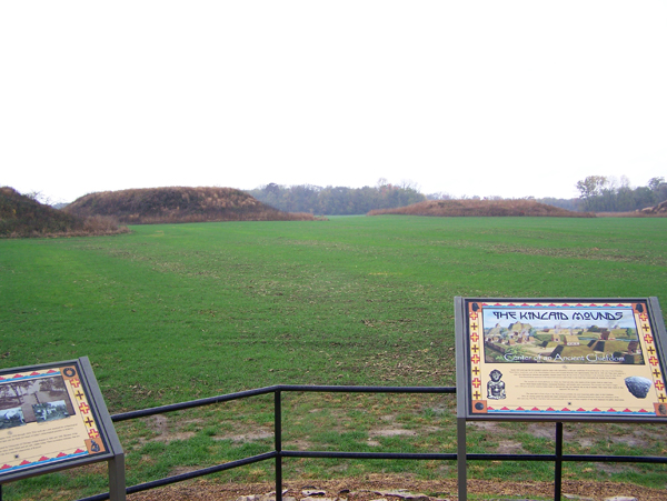
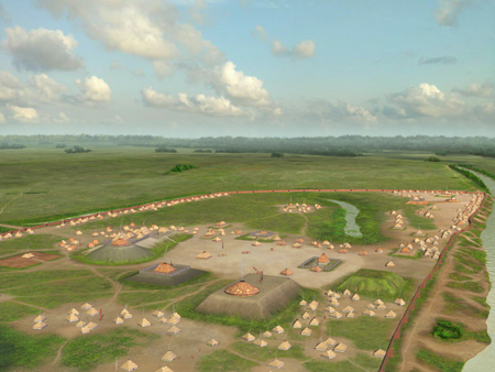
The Mississippian townspeople raised at least nineteen earthworks, most of them flat-topped platform mounds built in stages across some 350 years by stacking basket-loads of selected soil and clay. Surviving platform mounds range from about 8 feet to 30 feet high. The largest is almost 500 feet long — nothing beside Monks Mound at Cahokia, but very large by Mississippian standards, ranking twelfth in size among all known Mississippian mounds.
The mounds arc around a plaza that was itself engineered: filled and levelled to make the town’s principal public space. On the summits stood thatched buildings — chiefly residences, council houses and temples — while the plaza below hosted ceremony, politics and the chunkey game, and may have carried a ceremonial pole where war trophies were displayed. A wooden palisade enclosed an area estimated at about 141 acres, with further occupation spreading west beyond it. The palisade survives only in the archaeological record; nothing of it is visible today.
Mounds That Were Meant to Be Seen in Colour
Colour was part of the architecture. Research by Corin Pursell, who has worked at Kincaid since the early 2000s, has examined the deliberate use of differently coloured clays to face Mississippian mounds — surfaces that read as bright, patterned monuments rather than the uniform green humps visitors see now.
Life in the Kincaid Chiefdom: Maize, Chunkey and Chert
Kincaid was a hereditary chiefdom. Power passed within a ruling lineage, and the chief’s authority was very probably framed in solar terms, as elsewhere in the Mississippian world. The evidence for hierarchy is physical: in the 1930s the Chicago team excavated Pope Mound 2, a burial mound containing stone box graves and log-lined tombs of a kind common further south in the Middle Cumberland Valley of Tennessee — differentiated burial treatment for a differentiated society.
The artefacts point outward as well as upward. Carved figurines in coal and fluorite characterise local iconography, with imagery linking Kincaid to the Southeastern Ceremonial Complex, the shared religious symbolism of the Mississippian South. Chert was traded from Missouri, Tennessee and elsewhere in Illinois, while high-quality Mill Creek chert came from quarries close by. Kincaid potters produced distinctive negative-painted wares — the resist-decorated Kincaid Negative Painted type — alongside shell-tempered Mississippi Ware and finer Bell Ware.
The “Kincaid Focus”: Angel, Wickliffe and Tolu
Kincaid did not stand alone. Archaeologists group it with three other lower-Ohio Mississippian towns — Angel Mounds in Indiana, Wickliffe Mounds in Kentucky, and the Tolu site — into what is called the Kincaid focus, on the strength of shared pottery assemblages and near-identical site plans. The resemblance between Kincaid and Angel is close enough that some specialists have argued the two were built and occupied by people of the same society.
The 300-to-400-year span covered by these sites is known as the Angel phase, conventionally split into three subphases: Jonathan Creek (1000–1100/1200), Angelly (1200–1300) and Tinsley Hill (1300–1450). Shared diagnostic pottery types run across all four towns — Angel Negative Painted, Kincaid Negative Painted and Matthews Incised — though painted and incised sherds remain rare, under one per cent of the assemblage at Kincaid itself. Comparable regional centres elsewhere in the Mississippian world include Moundville in Alabama, Etowah in Georgia, Emerald Mound in Mississippi and Town Creek in North Carolina.
What Excavations Since 2003 Have Added
Southern Illinois University Carbondale returned to Kincaid in 2003, bringing geophysical survey and modern excavation to ground the Chicago team had already turned over. The most striking result was a mound the earlier crews had walked past. Chicago’s archaeologists had listed nine mounds in the Massac County portion and dug around one low rise without deciding what it was; in 2003 the SIU team identified it as a genuine artificial earthwork, later buried under a midden, lying near the road at the south-eastern corner of the plaza. Brian Butler and Paul Welch published the result in 2005 under the apt title “Mounds Lost and Found.”
Work has continued since, refining the town’s chronology, its domestic architecture and its diet. The lesson of the 2003 season is a useful corrective: even a site excavated for a decade by the people who wrote the manual can still be holding something back.
Abandonment, Protection and Visiting Today
Mississippian occupation at Kincaid appears to have ended by about 1400–1450 CE. No historic Native American tribe is documented as living on the site afterwards, and it stayed empty for roughly three centuries until American settlers arrived — most of them more than 400 years after the town was abandoned. Why it emptied is not settled. Exhaustion of timber and game in the surrounding bottomlands is one long-standing suggestion; regional instability and shifting political networks across the late Mississippian world are others. Kincaid left no written record, so the case is argued from soil, pottery and bone.
The Kincaid Site was designated a National Historic Landmark in 1964 and listed on the National Register of Historic Places in 1966. The state property is managed for the Illinois Historic Preservation Division by the Kincaid Mounds Support Organization, a local non-profit. Visitors should know before travelling that the mounds themselves are closed: public access is limited to an interpretive area and observation platform beside Kincaid Mounds Road, open dawn to dusk, reached via New Cut Road south of Route 45 past Unionville. The organisation also runs an annual archaeology field day each October. For more sites of this kind, browse our historical places collection.
At a Glance
- Country: United States (Massac and Pope counties, Illinois)
- Civilization: Mississippian culture (earlier Archaic, Baumer/Crab Orchard and Lewis occupations)
- Main occupation: c. 1050–1400/1450 CE
- Scale: at least 19 mounds; 11 substructure platform mounds plus 8 other monuments; largest almost 500 ft long; palisaded area c. 141 acres
- Excavated: University of Chicago 1934–1941 under Fay-Cooper Cole; Southern Illinois University from 2003
- Protection: National Historic Landmark 1964; National Register of Historic Places 1966
Sources
- Kincaid Mounds State Historic Site — Wikipedia
- Kincaid Mounds — Illinois Historic Preservation Division
- History — Kincaid Mounds Support Organization
- Cahokia — World History Encyclopedia
- Map of Mississippian and Related Cultures — World History Encyclopedia
- Mississippian culture — Wikipedia
- Fay-Cooper Cole — Wikipedia
For Paleoindian occupation far to the north-east of the Ohio valley mound country, see our guide to the ancient sites of New Hampshire and the 12,000-year-old dwellings at Tenant Swamp.

Neural Pathways is a collective of seasoned experts and researchers with a profound passion for unraveling the enigmas of ancient history and artifacts. With a wealth of combined experience spanning decades, Neural Pathways has established itself as a leading voice in the realm of archaeological exploration and interpretation.