Ancient civilization maps provide us with a fascinating glimpse into the past, revealing how our ancestors perceived their world and its geography. These historical treasures serve as an invaluable tool for understanding various aspects of ancient cultures, including trade routes, political boundaries, agricultural practices and even religious beliefs.
Examining a Few Examples:
- Nile-Centric Maps of Ancient Egypt: These maps showcased the Egyptians’ deep connection to the life-giving Nile River, a vital artery for their civilization.
- Intricate Road Systems of the Inca Empire: The Inca, known for their expansive empire in South America, meticulously charted their intricate road network on maps, facilitating communication and trade across their vast territory.
Beyond the Nile and the Andes:
Moving on to Asia’s oldest urban culture, the Indus Valley Civilization, which flourished around 2500 BC in what is now Pakistan and Western India. Archaeological findings suggest they had well-planned cities laid out in grid patterns, indicating advanced knowledge of urban planning. While there’s no definitive evidence of physical maps from this civilization, their urban design hints at a sophisticated understanding of space and place.
Similarly remarkable are ancient Greek maps, which not only showed geographical details but also incorporated elements of mythology. For instance, maps referencing Homer’s epic poem, the Odyssey, depicted places real or imagined within a cosmological framework.
Each map, whether a detailed depiction of the Nile or a mythological representation from the Greeks, serves as a testament to human ingenuity and thirst for exploration. These ancient maps reflect unique cultural perspectives on space and place during different epochs in history.
Map of the Inca Empire
This map illustrates the expansion of the Inca Empire, detailing its territorial growth under various emperors from 1438 CE to 1533 CE. The map is color-coded to show the extent of the empire during the reigns of different emperors.
Historical Context:
The Inca Empire, known as Tawantinsuyu in Quechua, was the largest empire in pre-Columbian America. It was highly organized and centralized, with advanced agricultural, architectural, and engineering practices. The empire’s downfall began with the Spanish conquest in the early 16th century, culminating in the capture and execution of Atahualpa in 1533. This map provides a visual representation of the empire’s expansion and the territories governed by successive emperors.
Key to the Map:
- Purple (1438 CE – 1463 AD): The expansion under Pachacuti, the ninth Sapa Inca (emperor). Pachacuti is credited with founding the Inca Empire, initiating its significant expansion from the small kingdom centered around Cusco.
- Dark Orange (1463 CE – 1471 AD): The territory added during the reign of Tupac Inca, Pachacuti’s son. Tupac Inca continued his father’s expansionist policies.
- Light Orange (1471 CE – 1493 AD): Further growth under Tupac Inca after assuming the role of emperor. This phase saw consolidation and additional territorial acquisitions.
- Green (1493 CE – 1525 AD): The significant enlargement of the empire during the rule of Huayna Capac, who extended the empire to its greatest territorial extent, reaching into present-day Ecuador and Colombia.
- Dark Green (1525 CE – 1532 AD): The areas controlled during the reign of Huascar, a period marked by internal strife and civil war.
- Light Blue (1532 CE – 1533 AD): The final phase of the empire under Atahualpa, during which the Inca Empire faced the Spanish conquest led by Francisco Pizarro.

Important Locations:
- Cusco: The capital of the Inca Empire, located in modern-day Peru, serving as the political and administrative heart of the empire.
- Lake Titicaca: A sacred site and an important cultural and economic region for the Incas.
- Quito, Cajamarca, Chavín de Huantar, Chan Chan, Pachacamac, Nazca, and Tiwanaku: Significant cities and cultural centers within the empire.
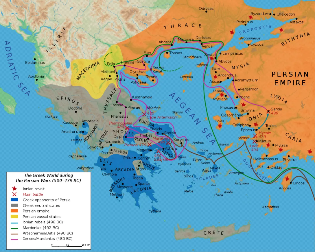
Map of Ancient Greece during the Persian Wars
This map depicts the Greek world during the Persian Wars (500-479 BC), highlighting the significant regions, key battles, and the territorial control of various states involved in the conflict between the Greek city-states and the Persian Empire.
Historical Context:
The Persian Wars were a series of conflicts between the Greek city-states and the Persian Empire. They began with the Ionian Revolt and included significant battles such as Marathon, Thermopylae, Salamis, and Plataea. The wars were pivotal in shaping Greek identity and demonstrated the unity and military prowess of the Greek city-states in the face of a powerful external enemy. This map provides a visual representation of the geopolitical landscape during this crucial period in ancient Greek history.
Key Features:
Regions and Territories:
- Macedonia: Depicted in yellow, indicating its involvement as a Persian vassal state.
- Thrace: Shown in orange, part of the Persian Empire.
- Ionia and Caria: Located on the western coast of Asia Minor, marked in orange to show their incorporation into the Persian Empire.
- Mainland Greece: Including regions like Thessaly, Epirus, Boeotia, Attica, and the Peloponnese.
Key City-States and Areas:
- Athens and Sparta: Major city-states leading the Greek resistance against Persia.
- Delphi, Thebes, and Corinth: Important Greek cities marked on the map.
- Ionian Revolt: Indicated by red stars, marking the cities involved in the revolt against Persian rule around 499 BC.
Key Battles and Routes:
- Marathon (490 BC): A significant battle where the Greeks defeated the Persians, marked with battle symbols.
- Thermopylae and Salamis (480 BC): Key battles during the second Persian invasion, also marked with battle symbols.
- Plataea (479 BC): The final land battle where the Greeks secured their victory over Persia.
Persian Campaigns:
- Ionian Revolt (499 BC): Initial conflict indicated by the movements of Ionian rebels.
- Artaphernes/Datis Campaign (490 BC): Marked in pink, showing the Persian invasion route during the first campaign, culminating in the Battle of Marathon.
- Xerxes/Mardonius Campaign (480 BC): Indicated in green, showing the major invasion route during the second Persian campaign, including battles at Thermopylae and Salamis.
Neutral and Opponent States:
- Greek Opponents of Persia: Marked in dark blue, including Athens and Sparta.
- Greek Neutral States: Indicated in grey, showing states that remained neutral during the conflicts.
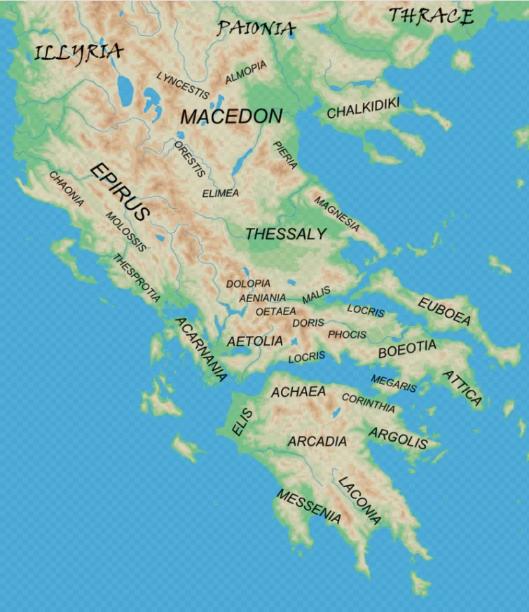
Map of Ancient Greece and the Barbarian Lands
This map depicts ancient Greece and the adjacent “barbarian” lands during classical antiquity. It highlights various regions, city-states, and neighboring territories that were significant during this period.
Historical Context:
Ancient Greece was a civilization characterized by a network of city-states (poleis), each with its own government and customs. While these city-states often united against common enemies, such as during the Persian Wars, they were also frequently at odds with each other, leading to conflicts like the Peloponnesian War.
The regions neighboring Greece, often referred to as “barbarian” lands by the Greeks, played crucial roles in the geopolitics of the time. These areas included various tribes and kingdoms that interacted with the Greek city-states through trade, warfare, and diplomacy.
This map provides a comprehensive view of the geographical and political landscape of ancient Greece and its surrounding areas, highlighting the complexity and diversity of this ancient civilization.
Key Features:
Regions and City-States of Ancient Greece:
Macedon (Macedonia): A significant kingdom in northern Greece, known for its powerful rulers such as Philip II and Alexander the Great. Key areas within Macedon include:
- Lynkestis
- Orestis
- Elimea
- Pieria
- Chalkidiki
Thessaly: A fertile region known for its horse breeding, important cities and regions include:
- Dolopia
- Aeniania
- Oetaea
- Maliss
- Malis
- Magnesia
Epirus: A rugged region in the northwest, home to the Molossian tribe and the famous oracle of Dodona.
- Chaonia
- Molossis
- Thesprotia
Aetolia and Acarnania: Located in western Greece, known for their fierce warriors and loose federations.
Central Greece: Includes several key regions and city-states:
- Boeotia: A region dominated by the city of Thebes.
- Attica: The region surrounding Athens, the heart of classical Greek culture.
- Phocis
- Doris
- Locris (divided into East and West Locrians)
Peloponnese: The southern peninsula, home to powerful city-states and regions:
- Achaea
- Elis
- Arcadia
- Argolis
- Laconia: Home to Sparta, one of the most famous military powers in ancient Greece.
- Messenia
Euboea: An important island with significant cities like Chalcis and Eretria.
Adjacent Barbarian Lands:
- Illyria: To the northwest, inhabited by various tribes known collectively as Illyrians.
- Paionia: To the north of Macedon, a region inhabited by the Paionians.
- Thrace: To the northeast, known for its fierce warriors and diverse tribes.
Map of Ancient Egypt
This two-part map depicts Ancient Egypt, including significant regions, cities, temples, and landmarks. It is divided into Upper Egypt, Lower Egypt, and the neighboring regions of Nubia and Kush.
Historical Context:
Ancient Egypt was one of the world’s earliest and most enduring civilizations, centered around the Nile River. The division between Upper and Lower Egypt was a significant aspect of its geography and culture, with distinct political and cultural identities. The neighboring regions of Nubia and Kush were also integral to Egypt’s history, often interacting through trade, warfare, and cultural exchange. This map provides a comprehensive overview of the geographical and cultural landscape of ancient Egypt and its surrounding regions.
Part 1: Lower Egypt and Upper Egypt (Northern Part)
This section of the map of Egypt in ancient times, highlights the regions from the Mediterranean Sea down through Lower Egypt to the northern part of Upper Egypt.
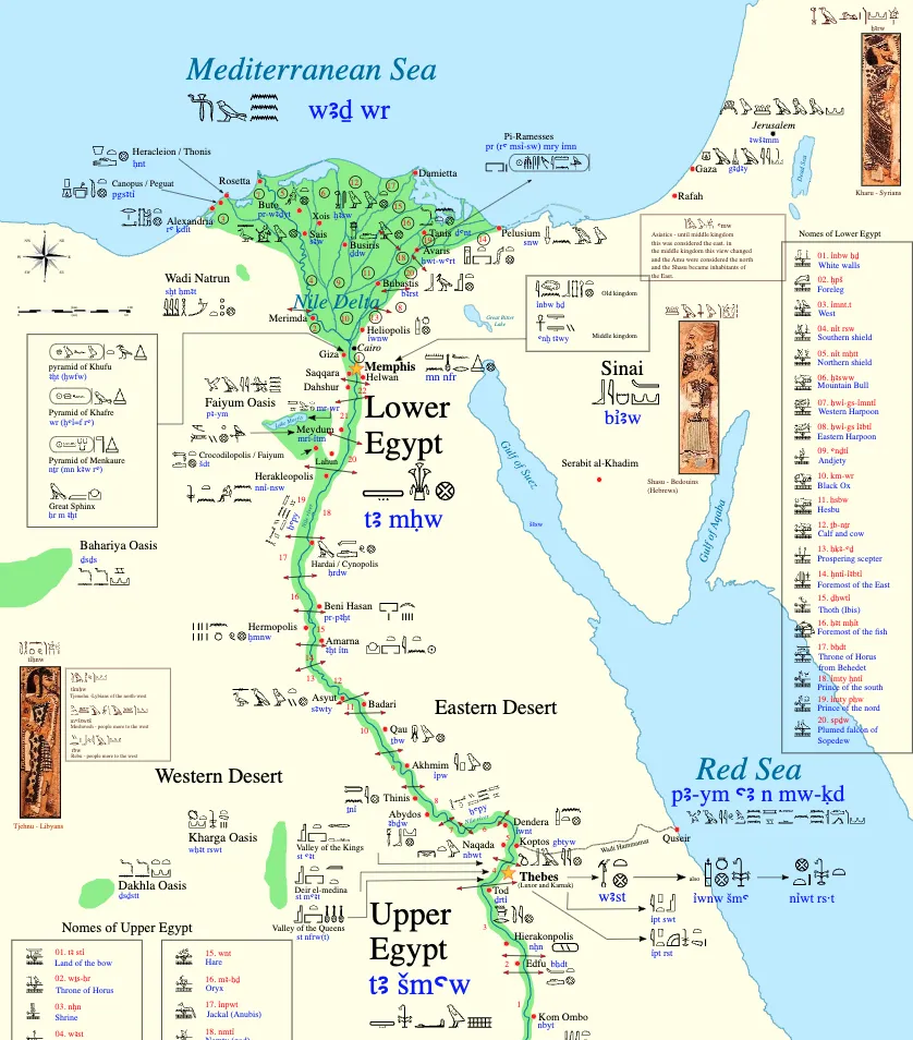
Lower Egypt:
- Nile Delta: The fertile area where the Nile River fans out before entering the Mediterranean. Key locations include:
- Alexandria: A major port city.
- Memphis: An important ancient capital near modern Cairo.
- Giza: Home to the famous pyramids and the Sphinx.
- Heliopolis: A major religious center.
- Sais, Bubastis, and Tanis: Significant cities in the delta region.
Upper Egypt (Northern Part):
- Faiyum Oasis: A fertile depression west of the Nile, known for its agricultural productivity.
- Heracleopolis: A significant city near the Faiyum.
- Thebes: A major city and religious center, home to the Karnak and Luxor temples.
- Abydos: A key religious site with important temples.
Neighboring Regions:
- Sinai Peninsula: Marked with key mining areas such as Serabit el-Khadim.
- Western Desert: Notable oases like Bahariya, Farafra, Dakhla, and Kharga.
Part 2: Upper Egypt (Southern Part) and Nubia
This section of the map covers the southern part of Upper Egypt and extends into Nubia and Kush.
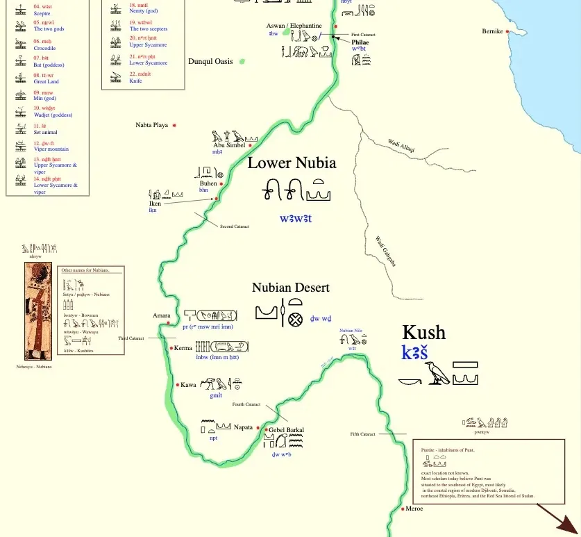
Upper Egypt (Southern Part):
- Aswan and Elephantine: Important southern border regions.
- Kom Ombo and Edfu: Cities known for their temples dedicated to Sobek and Horus.
- Philae: An island temple complex.
- Valley of the Kings: Located near Thebes, the burial site of many pharaohs.
- Dendera and Esna: Sites with significant temples.
Lower Nubia:
- Buhen and Wadi Halfa: Key border fortresses.
- Second Cataract: Natural barrier in the Nile.
Nubian Desert and Kush:
- Kerma: An ancient city and kingdom center in Nubia.
- Napata and Gebel Barkal: Key religious and cultural centers of the Kingdom of Kush.
- Meroe: The capital of Kush, known for its pyramids and iron production.
Additional Information:
- Hieroglyphic Inscriptions: The map includes numerous hieroglyphic labels and symbols, indicating the locations of temples, cities, and other significant sites.
- Nomes of Egypt: The map lists and marks the traditional administrative divisions of ancient Egypt, known as nomes.
- Landmarks and Features: Major landmarks such as pyramids, temples, and other ancient structures are highlighted, providing a detailed view of the ancient Egyptian civilization’s key sites.
Map of the Aztec Empire (1427-1520)
This map depicts the territorial expansion of the Aztec Empire, showing the regions and cities under its control during different periods of rule by various emperors. The Aztec Empire, centered around the capital city of Tenochtitlan, was one of the most powerful Mesoamerican civilizations until its conquest by the Spanish in the early 16th century.
Historical Context:
The Aztec Empire was a highly organized and militaristic society with a complex social structure and rich cultural heritage. The empire’s expansion was driven by a combination of military conquests, strategic alliances, and tributes from subjugated regions. The arrival of Spanish explorers and conquistadors, led by Hernán Cortés, marked the beginning of the end for the Aztec Empire, culminating in the fall of Tenochtitlan in 1521.
This map provides a comprehensive overview of the geographical extent and historical development of the Aztec Empire, illustrating the dynamic nature of its territorial expansion and the influence of its powerful rulers.
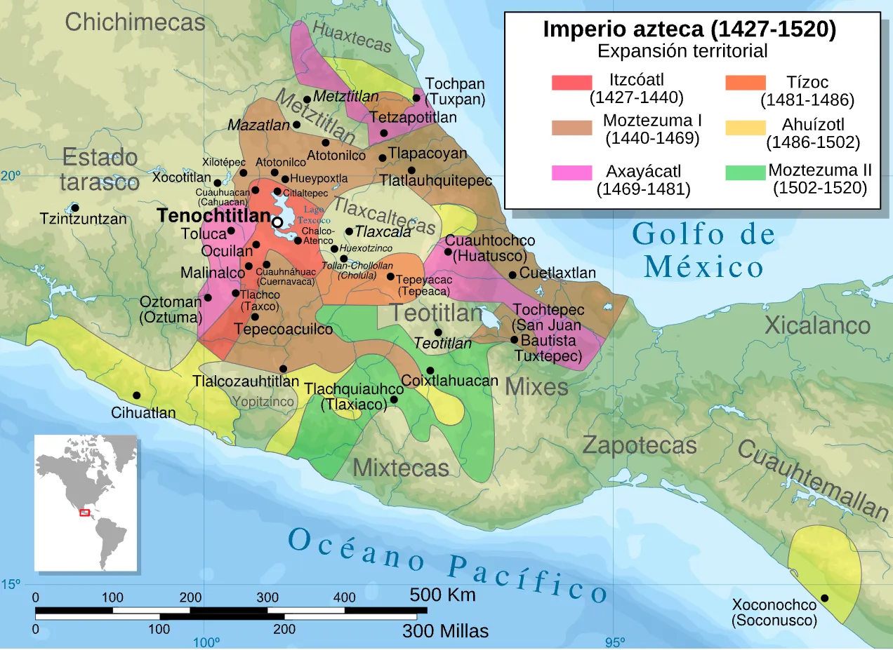
Key Features:
Regions and Cities:
- Tenochtitlan: The capital city of the Aztec Empire, located on an island in Lake Texcoco. It was the political, economic, and religious center of the empire.
- Texcoco and Tlacopan: Important allied city-states forming the Triple Alliance with Tenochtitlan.
- Key Cities and Regions: Other significant cities include Teotitlan, Tepeyacac, Tlaxcala, Huexotzinco, Malinalco, and Tezcoco.
Territorial Expansion:
The map uses different colors to represent the territorial expansion under various Aztec rulers:
- Itzcóatl (1427-1440): Territories conquered during his reign are marked in red. Itzcóatl was a key figure in establishing the foundation of the Aztec Empire by forming the Triple Alliance and beginning major conquests.
- Moctezuma I (1440-1469): Areas expanded under his rule are shown in brown. Moctezuma I significantly expanded the empire’s territories and strengthened its economic and military power.
- Axayácatl (1469-1481): Territories acquired during his reign are marked in pink. Axayácatl continued the expansion efforts and dealt with internal challenges.
- Tízoc (1481-1486): Regions conquered during his short reign are indicated in orange. Tízoc’s reign saw limited expansion compared to his predecessors.
- Ahuízotl (1486-1502): Territories expanded during his rule are shown in yellow. Ahuízotl was known for his extensive military campaigns and further significant expansions of the empire.
- Moctezuma II (1502-1520): Areas controlled under his reign are marked in green. Moctezuma II’s rule was notable for the empire’s peak in power and its eventual encounter with the Spanish conquerors.
Geographic and Cultural Context:
- Gulf of Mexico: The northeastern boundary of the Aztec Empire, influencing trade and cultural exchanges.
- Pacific Ocean: The southwestern boundary, providing resources and trade routes.
- Chichimecas and Huaxtecas: Neighboring regions inhabited by other indigenous groups, often in conflict or trade with the Aztec Empire.
- Mixtecs, Zapotecs, and other regions: Highlighting the diversity of Mesoamerican cultures and their interactions with the Aztecs.
Map of the Indus Valley Civilization (Mature Phase: c. 2600-1900 BCE)
This map illustrates the geographical extent and major sites of the Indus Valley Civilization during its mature phase. The civilization, known for its advanced urban planning, architecture, and social organization, flourished in the northwestern regions of South Asia.
Historical Context:
The Indus Valley Civilization is noted for its remarkable urban planning, with cities featuring grid patterns, advanced drainage systems, and well-built structures. The civilization engaged in extensive trade, both within the region and with distant lands like Mesopotamia. Its decline around 1900 BCE remains a subject of research, with theories suggesting climate change, river shifts, and invasions as potential causes.
This map provides a comprehensive overview of the geographical spread, major urban centers, and interactions with adjacent cultures, illustrating the complexity and sophistication of the Indus Valley Civilization.
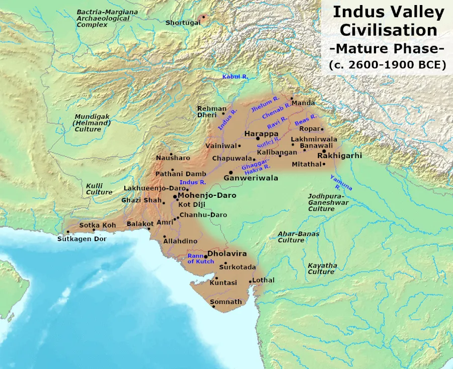
Key Features:
Major Sites:
- Harappa: One of the principal urban centers, located in present-day Punjab, Pakistan. It was a major hub of culture and commerce in the Indus Valley.
- Mohenjo-Daro: Another significant city located in Sindh, Pakistan, renowned for its advanced urban layout, including well-planned streets and sophisticated drainage systems.
- Ganweriwala: Located near the Ghaggar-Hakra River, it is one of the less explored major cities.
- Dholavira: Located in the Rann of Kutch, Gujarat, India, known for its unique water conservation system and impressive architecture.
- Rakhigarhi: Situated in Haryana, India, it is one of the largest Indus Valley Civilization sites discovered.
- Lothal: Located in Gujarat, India, it was a prominent port city known for its dockyard and trade with Mesopotamia.
- Kalibangan: Situated in Rajasthan, India, known for its pre-Harappan and Harappan phases of civilization.
Rivers and Geographical Features:
- Indus River: The primary river supporting the civilization, flowing through Pakistan.
- Ghaggar-Hakra River: An ancient river, believed to be the Sarasvati River mentioned in Vedic texts, which supported many settlements.
- Ravi, Sutlej, Beas, Chenab, and Jhelum Rivers: Major tributaries of the Indus River, supporting various settlements.
Adjacent Cultures:
- Bactria-Margiana Archaeological Complex (BMAC): Located to the northwest, indicating cultural and trade interactions.
- Mundigak (Helmand Culture): Located in present-day Afghanistan, showing the extent of cultural influence and trade.
- Kulli Culture: Located in southern Pakistan, highlighting interactions and cultural exchanges.
- Ahar-Banas, Kayatha, and Jodhpura-Ganeshwar Cultures: Located in present-day India, indicating the extent of influence and trade relations with neighboring cultures.
Key Locations:
- Shortugai: A trading outpost located in present-day Afghanistan, indicating trade links with Central Asia.
- Sutkagen Dor: A coastal site near the Arabian Sea, highlighting maritime trade.
Map of Ancient Mesopotamia
Map of Ancient Mesopotamia (c. 1200 BC)
This map illustrates the geographical and political landscape of Mesopotamia around 1200 BC, highlighting major regions, cities, and neighboring territories. Mesopotamia, known as the “cradle of civilization,” was home to some of the earliest and most influential civilizations in human history.
Historical Context:
Around 1200 BC, Mesopotamia was characterized by the presence of powerful city-states and empires, each vying for dominance. The Assyrian Empire was expanding its territory, while Babylonia remained a significant cultural and economic center. Elam, to the east, was a formidable rival and often interacted with Mesopotamian civilizations through both conflict and trade.
This period also witnessed the collapse of several ancient civilizations, often referred to as the Bronze Age collapse, which affected many regions, including the Hittite Empire and parts of the Levant.
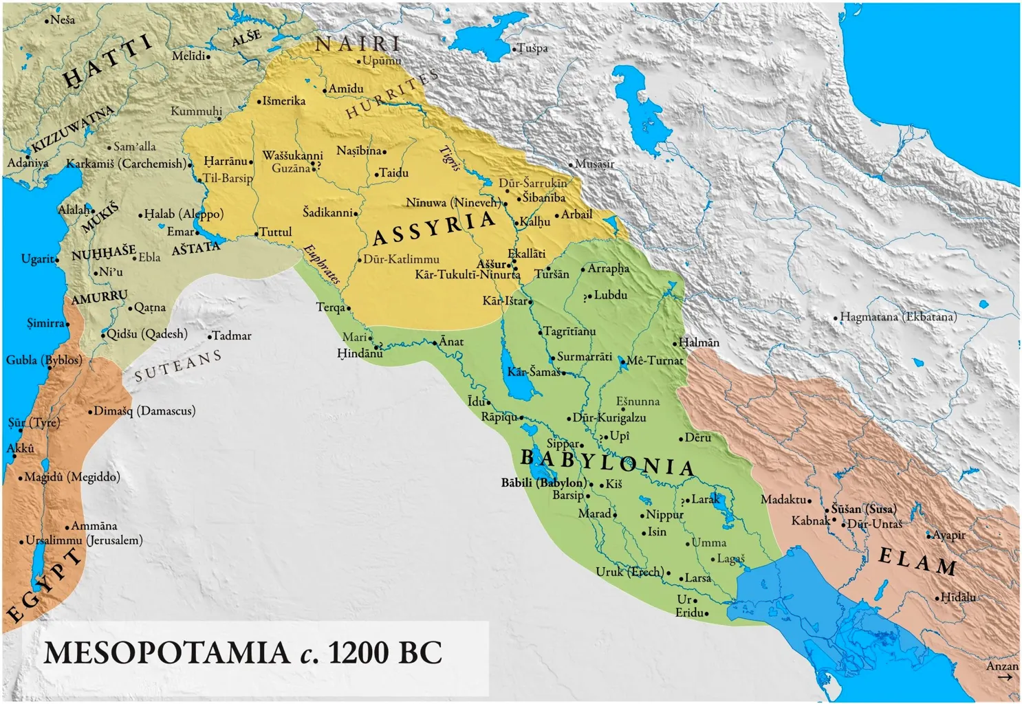
Key Regions and Civilizations:
Assyria:
- Assur (Aššur): The capital city and religious center of the Assyrian Empire.
- Nineveh (Ninua): A major city and later capital of the Assyrian Empire.
- Arbela (Erbil): Another significant city within Assyria.
- Dur-Sharrukin (Khorsabad): A capital city established by King Sargon II.
- Other notable cities: Kalhu (Nimrud), Kar-Tukulti-Ninurta, Dur-Katlimmu.
Babylonia:
- Babylon (Babili): The capital city, renowned for its impressive architecture and cultural achievements.
- Sippar: Known for its temple dedicated to the sun god Shamash.
- Nippur: A religious center dedicated to the god Enlil.
- Other significant cities: Kis, Borsippa, Isin, Larsa, Uruk (Erech), Ur, Eridu.
Elam:
- Susa (Šušan): The capital city of Elam, an important cultural and political center.
- Anshan: A significant city within the Elamite kingdom.
- Other locations: Madaktu, Kabnak (Haft Tepe), Dur-Untash (Chogha Zanbil).
Neighboring Regions:
- Hatti (Hittite Empire): Located to the northwest, including key cities such as Hattusa.
- Amurru: A region in western Mesopotamia and the Levant, including cities like Ugarit and Byblos.
- Egypt: Represented in the southwestern part, indicating its territorial influence extending into the Levant.
Geographic Features:
- Tigris and Euphrates Rivers: The two main rivers providing fertile land and supporting the development of civilizations.
- Zagros Mountains: Located to the east, forming a natural boundary for Mesopotamia.
- Arabian Desert: To the south, limiting the southern expansion of Mesopotamian cultures.
Map of the Ancient Maya Civilization
This map depicts the geographical extent of the Ancient Maya civilization, highlighting significant Classic and Postclassic sites. The Maya civilization, known for its advanced writing system, architecture, mathematics, calendar, and astronomical system, flourished in Mesoamerica.
Historical Context:
The Maya civilization experienced its peak during the Classic Period (c. 250-900 AD), with the construction of monumental architecture, development of complex societal structures, and advancements in various fields. The Postclassic Period (c. 900-1500 AD) saw the decline of many southern lowland cities and the rise of northern centers like Chichen Itza and Mayapan.
The Maya were adept at adapting to their diverse environment, building impressive cities in the rainforest, mountains, and coastal areas. They engaged in long-distance trade, spreading their cultural influence across Mesoamerica.
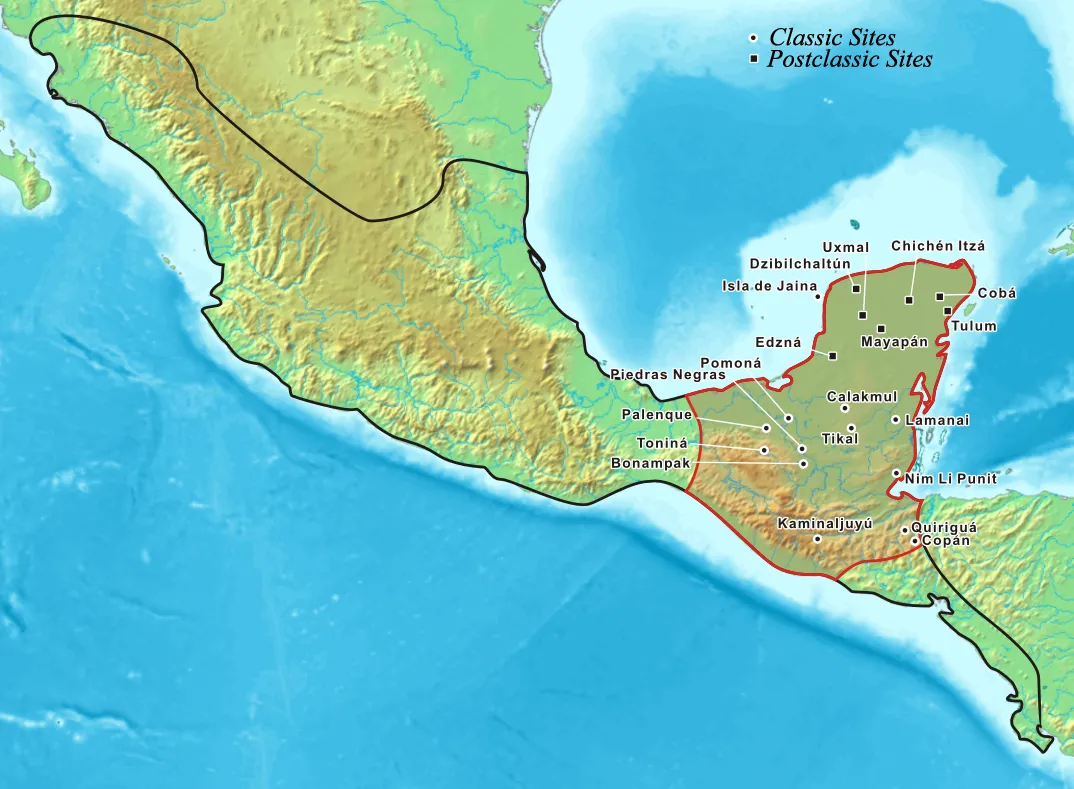
Key Features:
Classic Sites:
- Tikal: One of the most powerful city-states during the Classic Period, located in present-day Guatemala.
- Calakmul: A major rival of Tikal, situated in the Mexican state of Campeche.
- Copán: A notable Maya site located in present-day Honduras, known for its hieroglyphic stairway.
- Palenque: Located in Chiapas, Mexico, famous for its architectural and sculptural accomplishments.
- Bonampak: Known for its vivid murals depicting scenes of courtly life and warfare.
- Yaxchilan: Located along the Usumacinta River, known for its impressive architecture and sculptural works.
- Piedras Negras: Another significant site along the Usumacinta River, with notable stelae and altars.
- Quiriguá: Known for its large monuments and stelae, located in present-day Guatemala.
Postclassic Sites:
- Chichen Itza: One of the most famous Maya cities, located in the northern Yucatán Peninsula, known for its large pyramid, El Castillo.
- Mayapan: A major Postclassic site, known as the last great Maya capital.
- Uxmal: Known for its impressive Puuc-style architecture.
- Tulum: A walled city on the coast of the Yucatán Peninsula, known for its well-preserved ruins.
Additional Sites:
- Dzibilchaltún: An ancient Maya city near Mérida, Mexico, known for the Temple of the Seven Dolls.
- Edzná: A Maya archaeological site in Campeche, Mexico, with notable ceremonial structures.
- Cobá: An important city in the northeastern Yucatán Peninsula, known for its network of stone causeways.
- Lamanai: One of the largest Maya sites in Belize, continuously occupied for over 3,000 years.
- Kaminajuyú: An important site in the highlands of Guatemala, known for its extensive ruins.
- Nim Li Punit: Located in Belize, known for its stelae and architectural remains.
Geographic Context:
- Yucatán Peninsula: The heartland of the Maya civilization, encompassing parts of present-day Mexico, Belize, Guatemala, and Honduras.
- Gulf of Mexico: To the north, influencing trade and cultural exchanges.
- Pacific Ocean: To the south, providing resources and trade routes.
Map of the Roman Empire in 330 CE
This map illustrates the Roman Empire in 330 CE, highlighting the linguistic influence zones of Latin and Greek, and marking significant cities within the empire. This period was significant as it was just before the formal division into the Western and Eastern Roman Empires, a process that would be solidified later in 395 CE.
Historical Context:
In 330 CE, the Roman Empire was at a crucial point in its history. Emperor Constantine the Great had recently relocated the capital to Byzantium, renaming it Constantinople, which would later become the heart of the Byzantine Empire. This move was part of a broader strategy to better manage the empire’s vast territories and address the increasing threats from both external invasions and internal strife.
The division of the empire into Latin-speaking (western) and Greek-speaking (eastern) zones highlights the cultural and administrative differences that would eventually lead to the formal split into the Western Roman Empire and the Eastern Roman Empire (Byzantine Empire).
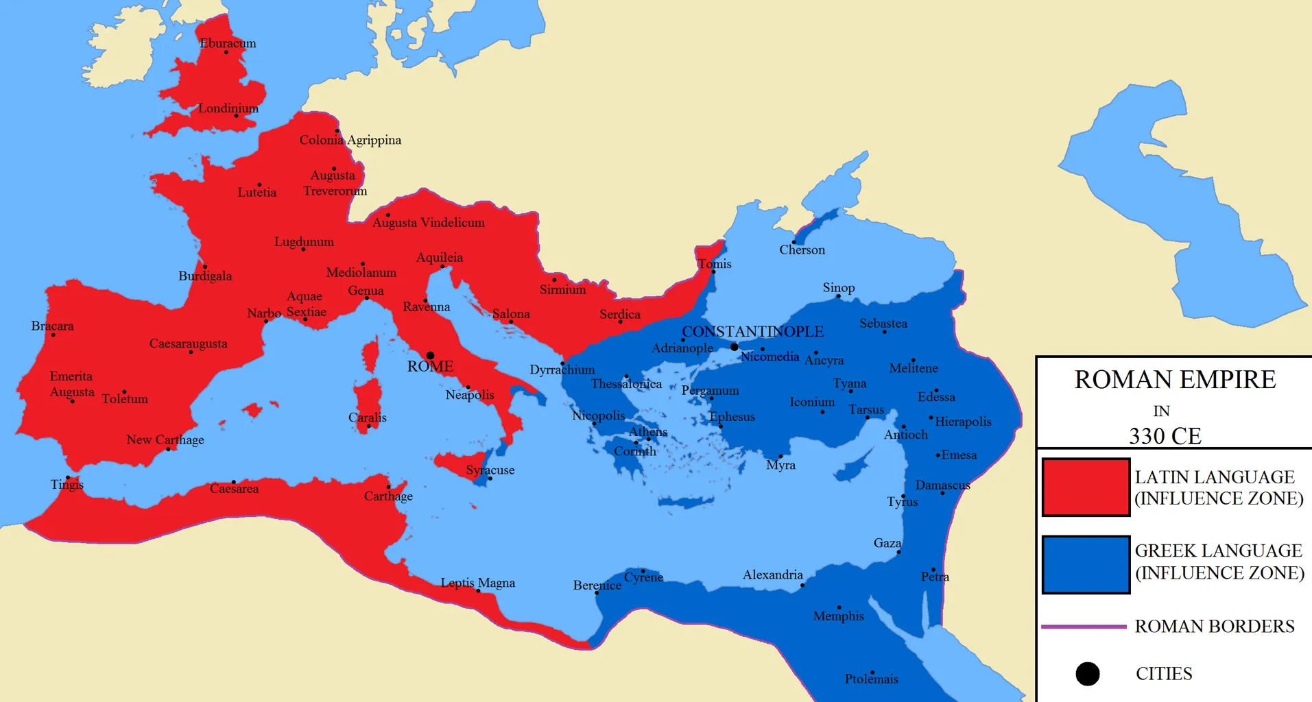
Key Features:
Latin Language Influence Zone:
- Western Roman Empire: The regions primarily influenced by the Latin language are marked in red, encompassing areas of present-day Western Europe and parts of North Africa.
- Notable Cities:
- Rome: The traditional capital of the Roman Empire and the cultural heart of the Latin-speaking world.
- Londinium (London): A major city in Roman Britain.
- Lutetia (Paris): The principal city of the Parisii tribe.
- Lugdunum (Lyon): An important administrative and military center in Gaul.
- Emerita Augusta (Mérida): A significant Roman city in Hispania.
- Carthage: A major city in North Africa, rebuilt by the Romans after the Punic Wars.
- Mediolanum (Milan): An important city in northern Italy.
- Colonia Agrippina (Cologne): A prominent city in the province of Germania Inferior.
- Notable Cities:
Greek Language Influence Zone:
- Eastern Roman Empire: The regions primarily influenced by the Greek language are marked in blue, covering areas of the Eastern Mediterranean, including parts of the Balkans, Anatolia, the Levant, and Egypt.
- Notable Cities:
- Constantinople (Byzantium/Istanbul): Established by Emperor Constantine the Great as the new capital of the Roman Empire in 330 CE, symbolizing the shift of power to the east.
- Antioch: A major city in the province of Syria, an important center of early Christianity.
- Alexandria: A major center of Hellenistic culture and learning in Egypt.
- Athens: Renowned for its cultural and philosophical contributions.
- Ephesus: A significant city in Asia Minor.
- Thessalonica: An important city in Macedonia.
- Nicopolis: A city founded by Augustus to commemorate his victory at the Battle of Actium.
- Cyzicus: A significant city in the region of Mysia, Asia Minor.
- Notable Cities:
Roman Borders:
- The purple line indicates the borders of the Roman Empire in 330 CE, stretching from the Atlantic Ocean in the west to the Black Sea and the Middle East in the east, encompassing much of Europe, North Africa, and the Near East.
Ancient India Map (North India in 540 BC)
This map illustrates the political landscape of North India in 540 BCE, highlighting the various kingdoms and regions as well as significant ports and cities. It provides a snapshot of the geopolitical context during the time of early Indian civilizations and the rise of significant kingdoms.
Historical Context
In 540 BC, North India was characterized by the presence of several Mahajanapadas, which were large, powerful kingdoms and republics that dominated the political landscape. This period saw the rise of urban centers, the development of trade routes, and significant cultural and religious advancements. The teachings of Mahavira (Jainism) and Buddha (Buddhism) also began to spread during this era, influencing the socio-political structures of these regions.
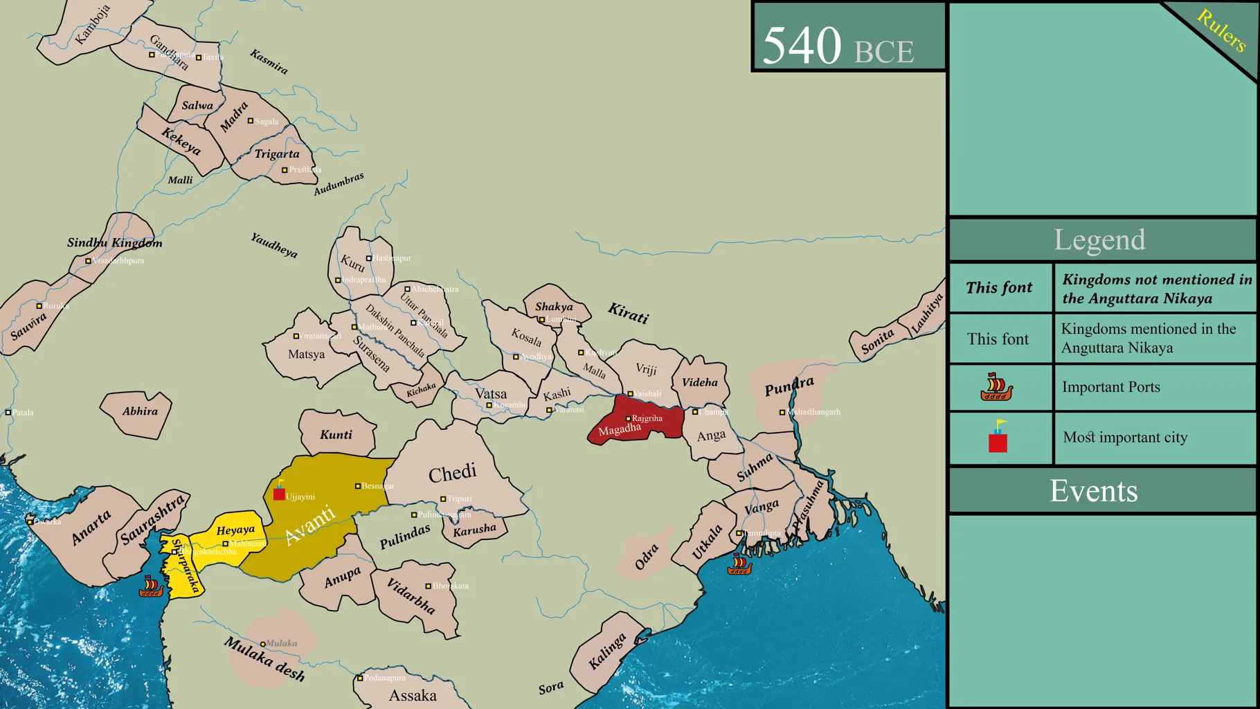
Key Features:
Kingdoms and Regions:
- Avanti: Marked in yellow, Avanti was one of the major Mahajanapadas (great kingdoms) of ancient India. Its capital was Ujjayini (Ujjain), a significant cultural and political center.
- Magadha: Marked in red, Magadha was another major Mahajanapada, with its capital at Rajgir (Rajagriha). It later played a crucial role in Indian history, being the birthplace of the Maurya and Gupta empires.
- Kosala: Located to the north of Magadha, Kosala included important cities like Ayodhya and Sravasti.
- Vatsa: Located near modern-day Allahabad, Vatsa was another influential Mahajanapada with its capital at Kaushambi.
- Kuru: Situated in the region corresponding to modern Haryana and Delhi, Kuru was an important Vedic kingdom with its capital at Indraprastha.
- Panchala: Located to the east of Kuru, Panchala was divided into northern and southern parts, with significant cities like Kampilya and Ahichhatra.
- Surasena: Located around the region of Mathura, Surasena was an important kingdom with Mathura as its capital.
- Malla: An ancient republic in the region of modern-day Gorakhpur and Deoria in Uttar Pradesh.
- Videha: Located in modern-day Bihar and Nepal, with Mithila as its capital.
- Anga: Situated to the east of Magadha, with its capital at Champa.
- Other notable regions: Gandhara, Kamboja, Sindhu Kingdom, Matsya, Chedi, Saurashtra, and Kalinga.
Important Ports:
- Sopara: An important ancient port city located in the present-day state of Maharashtra.
- Tamralipta: Another significant port located in the region of modern-day West Bengal.
Most Important Cities:
- Rajgir (Rajagriha): The capital of Magadha, marked as the most important city.
- Ujjayini (Ujjain): The capital of Avanti, also marked as a significant city.
Geographic Context:
- Rivers: The map shows major rivers such as the Ganges (Ganga), Yamuna, and their tributaries, which were crucial for the sustenance and development of these kingdoms.
- Himalayas: The northern boundary of the map is marked by the Himalayas, providing a natural barrier and influencing the climate and culture of the region.
Map of the Fertile Crescent
This map illustrates the region known as the Fertile Crescent, a historically significant area that is often referred to as the “Cradle of Civilization” due to its early developments in agriculture, writing, trade, and urbanization.
Historical Context:
The Fertile Crescent was a hub of early human civilization, where numerous cultures and empires emerged and flourished. The region’s fertile land and access to water resources supported the growth of agriculture, which in turn facilitated the rise of cities and complex societies. The strategic location of the Fertile Crescent also made it a crossroads for trade and cultural exchange, influencing regions far beyond its borders.
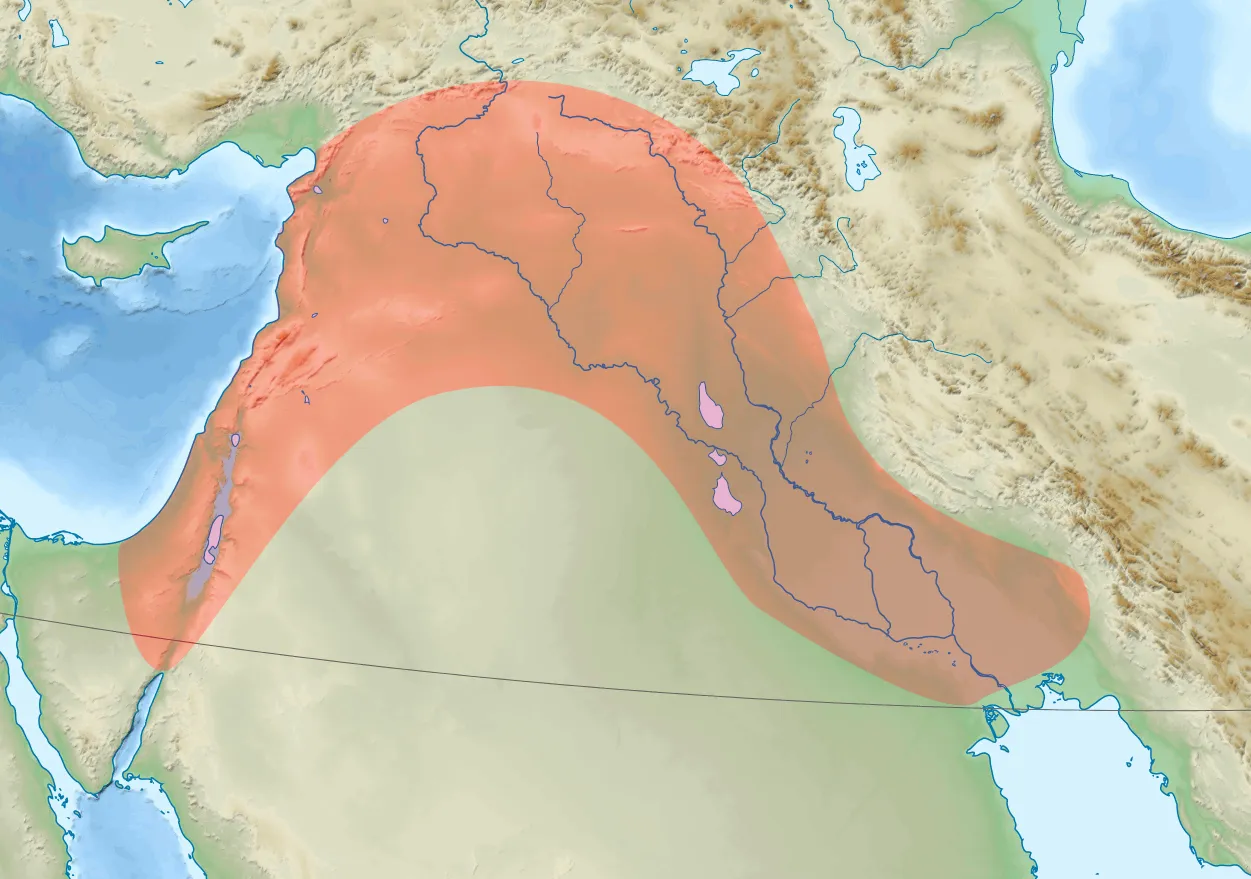
Key Features:
Geographic Extent:
- Western Arc: Extending from the southeastern coast of the Mediterranean Sea, including parts of modern-day Israel, Palestine, Lebanon, and Syria.
- Eastern Arc: Stretching through the Tigris and Euphrates river valleys, encompassing regions of modern-day Iraq and parts of Iran and Kuwait.
Major Rivers:
- Tigris River: One of the principal rivers of Mesopotamia, flowing through modern-day Iraq and joining the Euphrates River.
- Euphrates River: Another major river of Mesopotamia, running parallel to the Tigris and providing essential water resources for agriculture and settlement.
Key Regions and Civilizations:
- Mesopotamia: The land between the Tigris and Euphrates rivers, home to some of the earliest known civilizations, including Sumer, Akkad, Babylon, and Assyria. Notable cities include:
- Sumer: Known for the city-states like Ur, Uruk, and Eridu, recognized for developing the first known writing system, cuneiform.
- Akkad: The region that formed the Akkadian Empire, one of the world’s first empires under Sargon of Akkad.
- Babylon: Famous for the city of Babylon, the Hanging Gardens, and the Code of Hammurabi.
- Assyria: A powerful kingdom and later empire, known for its military prowess and cities like Nineveh and Assur.
- Levant: The western part of the Fertile Crescent, encompassing modern-day Israel, Palestine, Lebanon, and Syria. Key historical sites include:
- Jericho: One of the oldest continuously inhabited cities in the world.
- Byblos: An ancient Phoenician city known for its trade and early alphabet.
- Damascus: One of the oldest continuously inhabited cities, serving as an important cultural and trade center.
Significance of the Fertile Crescent:
- Agricultural Revolution: The Fertile Crescent is where some of the earliest developments in agriculture took place, including the domestication of plants and animals. This led to the establishment of settled communities and the rise of complex societies.
- Urbanization: The development of cities and city-states in this region marked significant advancements in human civilization, including the creation of governance systems, monumental architecture, and social stratification.
- Cultural and Technological Innovations: The region saw the invention of writing (cuneiform in Mesopotamia), the wheel, early mathematics, and astronomy. It also played a crucial role in the spread of ideas and technologies through trade and conquest.
Map of the Etruscan Civilization
This map illustrates the territory of the Etruscan civilization, highlighting key cities and neighboring regions in ancient Italy. The Etruscans were a significant pre-Roman civilization known for their rich culture, advanced engineering, and influence on Roman society.
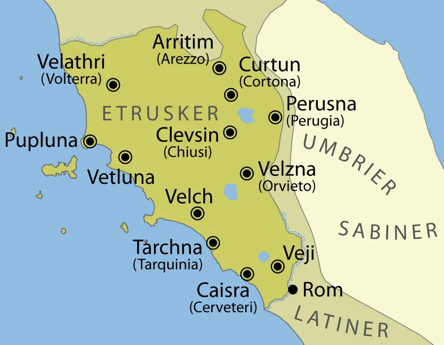
Key Features:
Major Etruscan Cities:
- Velathri (Volterra): An important Etruscan city known for its strong defensive walls and significant archaeological remains.
- Arritim (Arezzo): Known for its metalworking and pottery.
- Curtun (Cortona): A major urban center with substantial fortifications.
- Perusna (Perugia): One of the main cities, noted for its well-preserved Etruscan walls and tombs.
- Clevsin (Chiusi): A significant center of Etruscan civilization, known for its extensive necropolis.
- Velzna (Orvieto): Considered one of the primary religious centers, it is associated with the Fanum Voltumnae, the central sanctuary of the Etruscans.
- Vetluna (Vetulonia): An important urban center known for its archaeological sites and artifacts.
- Tarchna (Tarquinia): Famous for its richly decorated tombs and extensive necropolis, providing valuable insights into Etruscan art and culture.
- Caisra (Cerveteri): Known for its large necropolis and impressive tomb architecture.
- Veji (Veii): An influential city located close to Rome, known for its significant role in early conflicts with the Roman Kingdom.
- Rom (Rome): Originally an Etruscan city before becoming the center of the Roman Kingdom and later the Roman Republic and Empire.
Geographic Context:
- Tuscany and Lazio: The heartland of the Etruscan civilization, corresponding to modern-day regions of Tuscany, Lazio, and parts of Umbria.
- Adjacent Regions:
- Umbrici (Umbrians): Located to the northeast of the Etruscan territory.
- Sabini (Sabines): Positioned to the southeast.
- Latini (Latins): To the south, including the city of Rome, which was heavily influenced by Etruscan culture and politics.
Cultural and Historical Significance:
- Etruscan Influence: The Etruscans significantly influenced early Roman culture, including religious practices, architecture (such as the arch), and political symbols like the fasces.
- Urban Development: The Etruscans were skilled city planners and builders, with well-developed cities featuring advanced infrastructure, including roads, bridges, and drainage systems.
- Art and Religion: Known for their distinctive art, especially in pottery, metalwork, and frescoes. They practiced elaborate religious rituals and built impressive tombs, which were richly decorated and provided insights into their beliefs and daily life.
- Conflicts with Rome: The Etruscans often engaged in both alliances and conflicts with the emerging Roman state. Key cities like Veii were significant rivals of Rome before their eventual incorporation into the Roman Republic.
Map of the Olmec Civilization
This map illustrates the key sites and regions associated with the Olmec civilization, an influential Mesoamerican culture known for its monumental sculpture, sophisticated art, and early development of writing and urban planning.
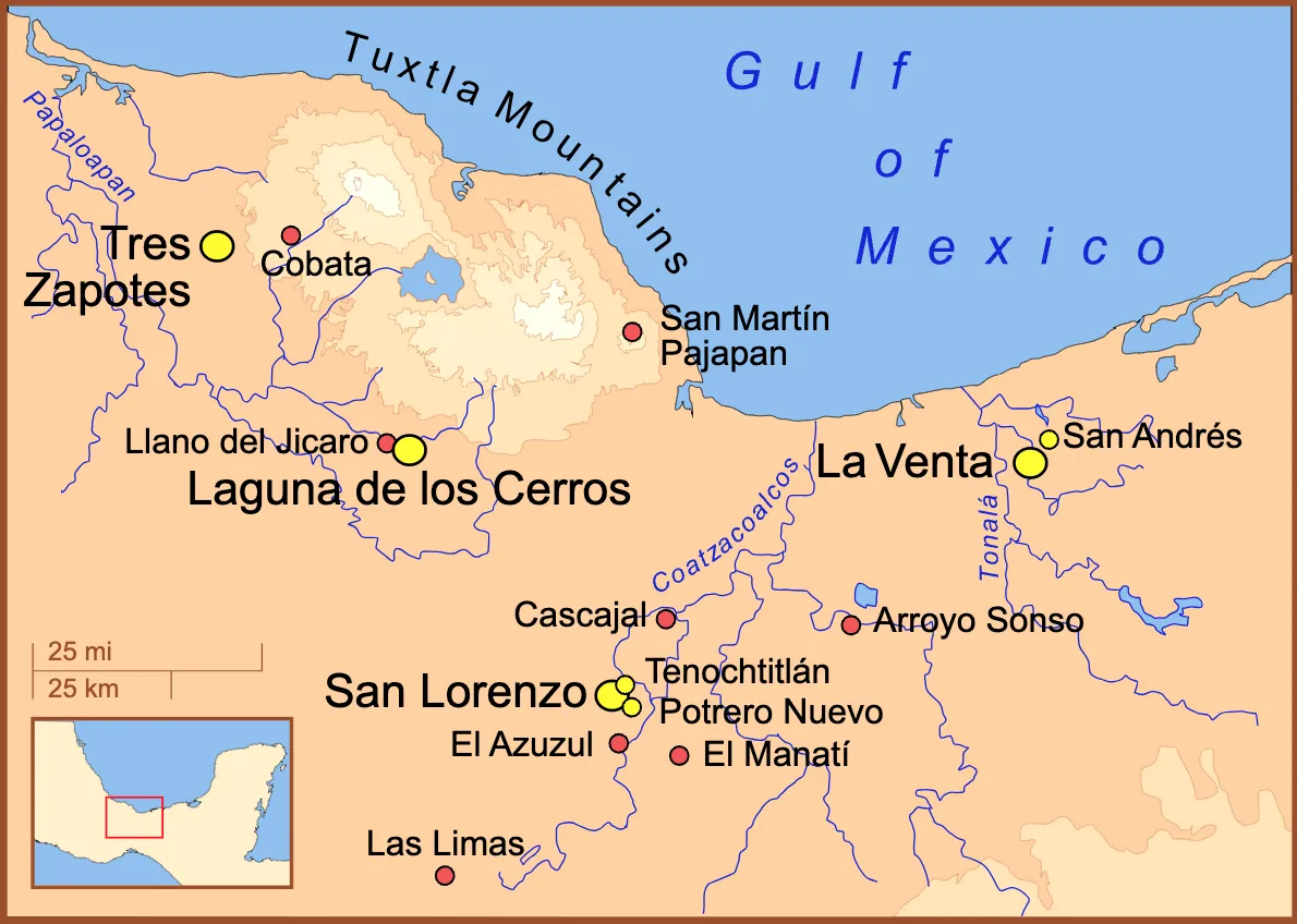
Key Features:
Major Olmec Sites:
- San Lorenzo: One of the earliest and most significant Olmec centers, located near the present-day city of Veracruz. San Lorenzo is known for its colossal heads, large earthen mounds, and complex water drainage systems.
- La Venta: A major Olmec site located in the present-day state of Tabasco. La Venta is famous for its large pyramid, colossal heads, and intricate stone carvings. It served as a religious and political center.
- Laguna de los Cerros: Another important Olmec center located in the present-day state of Veracruz. This site is known for its extensive architectural remains and numerous artifacts.
- Tres Zapotes: Located in the present-day state of Veracruz, Tres Zapotes is known for its long occupation and the discovery of the Long Count calendar, which provides important chronological information about the Olmec civilization.
- Las Limas: Noted for the discovery of the Las Limas Monument, an important artifact representing Olmec art and iconography.
- El Manatí: A significant Olmec site known for its ritual offerings, including wooden artifacts, rubber balls, and infant burials.
- San Andrés: Known for its association with La Venta and significant findings related to early writing and symbolism in Mesoamerica.
Geographic Context:
- Gulf of Mexico: The northern boundary of the Olmec heartland, influencing trade and cultural exchanges.
- Tuxtla Mountains: A key geographical feature providing resources such as basalt, used for creating monumental sculptures.
- Rivers: The map shows significant rivers, including the Coatzacoalcos and Tonalá rivers, which were crucial for transportation, trade, and sustaining agricultural practices.
Cultural and Historical Significance:
- Colossal Heads: The Olmecs are renowned for their colossal stone heads, believed to represent rulers or important figures. These heads, carved from basalt, demonstrate advanced artistic and engineering skills.
- Art and Iconography: Olmec art includes intricate carvings, jade figurines, and pottery, often depicting deities, animals, and mythological themes. Their iconography influenced later Mesoamerican cultures.
- Urban Planning: The Olmec centers demonstrate early forms of urban planning, with organized layouts, ceremonial centers, and sophisticated infrastructure such as drainage systems.
- Religion and Rituals: The Olmecs practiced complex religious rituals, including offerings and human sacrifices, as evidenced by the artifacts found at sites like El Manatí and La Venta.
- Influence on Mesoamerica: The Olmecs are considered the “mother culture” of Mesoamerica, as their cultural practices, artistic styles, and technological innovations influenced subsequent civilizations, including the Maya and the Aztecs.
Map of Viking Territories and Expeditions
This map illustrates the extent of Viking territories and their major expeditions during the Viking Age, highlighting key settlements and trade routes from the 8th to the 11th centuries.
Historical Context:
The Viking Age (c. 793-1066) was characterized by Norse seafaring, exploration, trade, and settlement across vast regions of Europe, the North Atlantic, and even North America. Vikings from Scandinavia ventured out on longships, establishing trade routes, colonies, and engaging in raids that significantly impacted the regions they encountered.
Viking society was highly skilled in navigation and maritime technology, allowing them to explore distant lands and establish extensive trade networks. They played a crucial role in the cultural and economic exchanges between different regions, contributing to the shaping of medieval Europe.

Key Features:
Major Viking Settlements and Regions:
- Scandinavia: The heartland of the Viking civilization, encompassing modern-day Norway, Sweden, and Denmark. Key regions include:
- Norway: From where many Viking explorers and traders originated.
- Sweden: Known for its eastward expansion into Eastern Europe and Russia.
- Denmark: A base for Viking incursions into Western Europe.
Key Settlements and Colonies:
- Iceland: Settled by Norse Vikings around 870, becoming a major center of Viking culture and exploration.
- Greenland: Discovered and settled by Erik the Red in 982, serving as a stepping stone for further exploration westward.
- Vinland: The name given to parts of North America explored by Leif Erikson around 1000, believed to be located in present-day Newfoundland, Canada.
- Faroe Islands: Settled by Vikings, providing a base for further exploration into the North Atlantic.
- Shetland and Orkney Islands: Important Viking strongholds in the North Atlantic.
Key Viking Expeditions and Trade Routes:
- Westward Expansion:
- Dublin (795): Established as a major Viking settlement and trading hub in Ireland.
- York (Jorvik) (820): Captured and transformed into a significant Viking city in England.
- Normandy (911): The region granted to Viking leader Rollo, forming the Duchy of Normandy in present-day France.
- Faroe Islands, Shetland Islands, Iceland, Greenland, and Vinland: Major westward routes and settlements showing the extent of Viking exploration.
- Eastward Expansion:
- Staraya Ladoga (820): A major trading post in present-day Russia.
- Novgorod (854): A significant center of Viking trade and settlement in Eastern Europe.
- Kiev (882): Captured by Vikings, becoming the capital of the Kievan Rus’.
- Volga River (880): Routes leading to the Caspian Sea, showing Viking trade and exploration in Eastern Europe and beyond.
- Miklagard (Constantinople) (839): The name given by Vikings to Constantinople, highlighting their involvement in trade and service as mercenaries in the Byzantine Empire.
- Southern Expansion:
- Rhine, Dnieper, Dniester, Danube, and Volga Rivers: Major rivers used by Vikings for trade and raids, connecting Scandinavia with Europe, Byzantium, and the Islamic Caliphates.
Map of Ancient Israel and Neighboring Kingdoms
This map illustrates the geopolitical landscape of ancient Israel and its neighboring kingdoms during the Iron Age, around the time of the divided monarchy (Kingdom of Israel and Kingdom of Judah).
Historical Context:
During this period, the region was marked by the presence of multiple small kingdoms and city-states, each with its own political and cultural identity. The Kingdom of Israel and the Kingdom of Judah were significant players, often involved in conflicts and alliances with their neighbors, including the Philistines, Moabites, Ammonites, Edomites, and Arameans. The larger empires, such as Assyria, exerted considerable influence over the region, often imposing tribute and exerting military pressure.
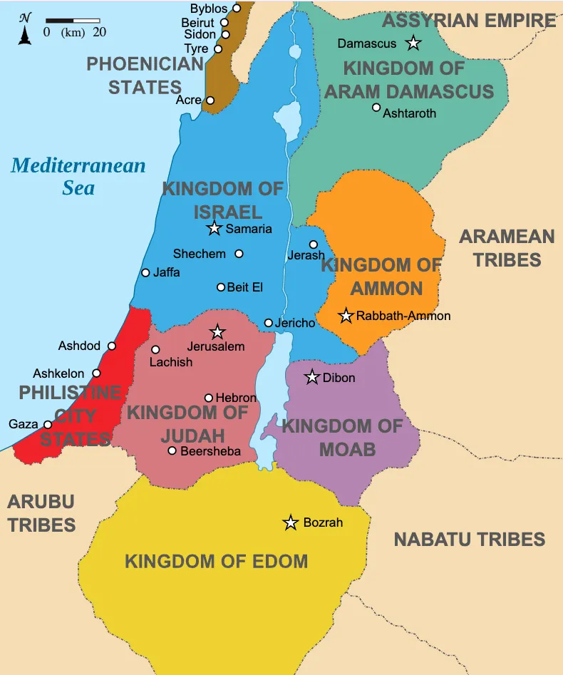
Key Features:
Major Kingdoms and Regions:
- Kingdom of Israel: Located in the northern part of the region, with significant cities including:
- Samaria: The capital city.
- Shechem: An important cultural and religious center.
- Beit El: Another significant religious site.
- Jaffa: A major port city on the Mediterranean coast.
- Jerash: Located on the eastern boundary.
- Kingdom of Judah: Situated to the south of the Kingdom of Israel, with key cities such as:
- Jerusalem: The capital city, central to the religious and political life of Judah.
- Hebron: An important historical and religious city.
- Lachish: A major fortified city.
- Beersheba: The southernmost city in the kingdom.
- Ashdod and Ashkelon: Cities located on the coastal boundary, marking the edge of Philistine influence.
- Kingdom of Ammon: Located to the east of Israel and Judah, with its capital at:
- Rabbath-Ammon (modern-day Amman, Jordan).
- Kingdom of Moab: Situated to the southeast of Israel, with key cities including:
- Dibon: The capital city.
- Jericho: Located at the northwestern boundary.
- Kingdom of Edom: Located to the south of Moab and Judah, with its capital at:
- Bozrah: The major city.
Neighboring Tribes and States:
- Philistine City-States: Located along the southern Mediterranean coast, these city-states include:
- Gaza
- Ashdod
- Ashkelon
- Phoenician States: Situated along the northern Mediterranean coast, known for their maritime trade and influence, including cities like:
- Byblos
- Tyre
- Sidon
- Acre
- Beirut
- Kingdom of Aram-Damascus: To the northeast, with its capital at:
- Damascus: A major city-state and rival to Israel.
- Ashtaroth: Another significant city.
- Assyrian Empire: Located to the northeast, a major regional power influencing the politics of smaller kingdoms.
- Aramean Tribes: Located to the east of Aram-Damascus.
- Nabatu Tribes and Arubu Tribes: Located to the south and southeast, respectively.
Geographic Context:
- Mediterranean Sea: The western boundary, crucial for trade and cultural exchange.
- Desert Regions: Including the Negev Desert to the south, marking the boundary of the settled areas.
Map of Medieval Europe (circa 1092 AD)
This map illustrates the geopolitical landscape of medieval Europe around 1092 AD, highlighting the major kingdoms, principalities, and empires of the time. The period is marked by the fragmentation of territories and the rise of feudal states following the decline of the Carolingian Empire.
Historical Context:
The early 12th century was a period of significant change and development in Europe. The feudal system was firmly established, with local lords wielding significant power. The Crusades were beginning, marking a period of intense interaction between Christian Europe and the Islamic world. The Byzantine Empire was experiencing both internal strife and external pressures, particularly from the Seljuk Turks.
This period also saw the rise of powerful monarchies in France, England, and the Holy Roman Empire, as well as the continued fragmentation and decentralization of power in other regions. The map highlights the diverse and dynamic political landscape of medieval Europe, reflecting the complexities of alliances, conflicts, and cultural exchanges that shaped the continent.
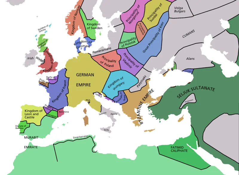
Key Features:
Major Kingdoms and Empires:
- German Empire: Also known as the Holy Roman Empire, encompassing much of Central Europe, including modern-day Germany, Austria, Switzerland, the Low Countries, and parts of Italy and France.
- Kingdom of France: One of the most powerful and influential kingdoms in medieval Europe, located in Western Europe.
- Byzantine Empire: The continuation of the Eastern Roman Empire, centered in Constantinople, covering parts of the Balkans, Anatolia, and the eastern Mediterranean.
- Seljuk Sultanate: A major Islamic state stretching across parts of the Middle East and Anatolia, exerting significant influence in the region.
- Fatimid Caliphate: An Islamic caliphate based in North Africa, extending its influence across parts of the Mediterranean.
- Kingdom of Hungary: A significant Central European power, located in the Carpathian Basin.
- Kingdom of Denmark: Covering the Scandinavian region, including parts of modern-day Denmark and southern Sweden.
Principalities and Smaller States:
- Principality of Poland: Located in Central Europe, a precursor to the Kingdom of Poland.
- Kingdom of Leon and Castile: Important Christian kingdoms on the Iberian Peninsula, instrumental in the Reconquista.
- Duchy of Normandy: A powerful duchy in northern France, known for its Viking heritage and the Norman Conquest of England in 1066.
- Principality of Kiev: A major East Slavic state and cultural center, located in present-day Ukraine.
- Principality of Novgorod: An important medieval Russian state known for its trade and political structure.
Other Notable Regions:
- Kingdom of Sweden: Covering the Scandinavian region, known for its Viking heritage.
- Murabit Emirate: A Berber empire in North Africa, known for its influence on the Iberian Peninsula.
- Kingdom of Scotland: Located in the northern part of the British Isles, an emerging medieval kingdom.
- Kingdom of England: An important power in the British Isles, having been recently unified under Norman rule.
Geographic Context:
- Mediterranean Sea: A crucial area for trade and cultural exchange between Europe, North Africa, and the Middle East.
- North Sea and Baltic Sea: Important for trade and naval activities in Northern Europe.
- Rivers: Major rivers like the Rhine, Danube, and Dniester facilitated trade and communication across Europe.
Map of the Ancient Near East around 1900 BC
This map depicts the geopolitical landscape of the Ancient Near East around 1900 BC, highlighting the major kingdoms, city-states, and cultural regions of the time. This period is characterized by the emergence and interaction of various powerful states and cultures.
Around 1900 BC, the Near East was a complex tapestry of emerging and established states, each contributing to the cultural and political dynamics of the region. Egypt’s Middle Kingdom was a period of reconsolidation and stability. In Mesopotamia, the Amorites were establishing new dynasties, while cities like Mari and Ebla played crucial roles in regional politics. The Minoans were flourishing on Crete, developing a distinct and influential culture. Trade networks facilitated interactions between these diverse cultures, fostering economic and cultural exchanges.
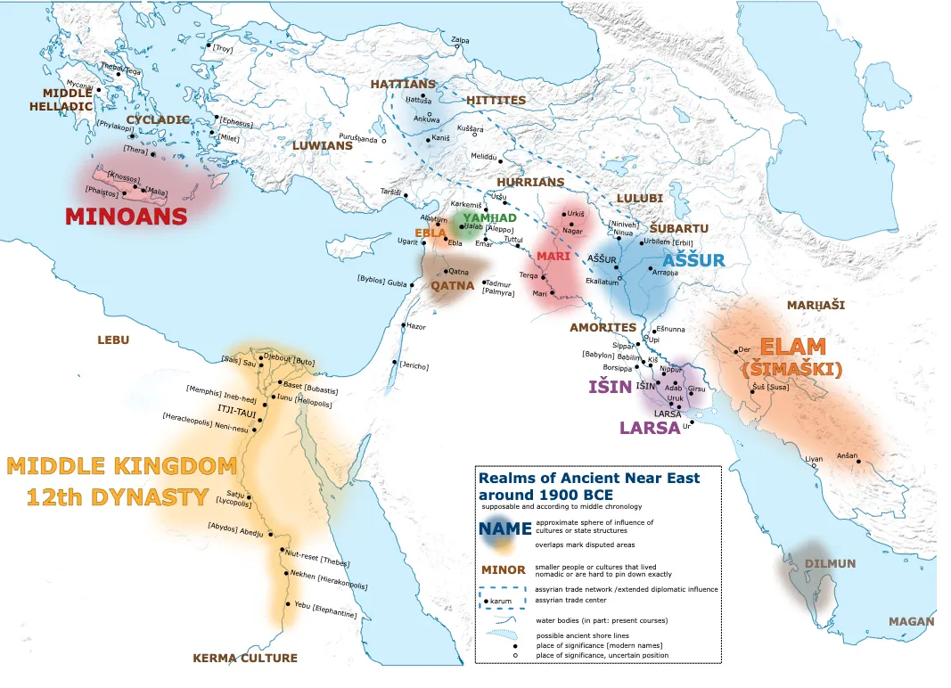
Key Features:
Major Kingdoms and City-States:
- Middle Kingdom (12th Dynasty) of Egypt:
- Itj-Tawi: The capital city located near modern-day Lisht.
- Memphis: An important cultural and political center.
- Thebes: Another significant city in Upper Egypt.
- Elephantine: Located at the southern border near Nubia.
- Minoan Civilization:
- Knossos: The major city on the island of Crete, known for its advanced architecture and complex society.
- Phaistos and Malia: Other important Minoan sites.
- Cycladic and Middle Helladic Cultures: Located in the Aegean Sea and mainland Greece, respectively.
- Hittites and Hattians:
- Hattusa: The capital city of the Hittites.
- Alaca Höyük and Kültepe: Significant sites in Hittite and Hattian territories.
- Luwians: An Anatolian people located in western and southern Turkey.
- Hurrians: Located in the northern Mesopotamian region.
- Urkesh and Nagar: Important Hurrian cities.
- Yamhad (Aleppo): A prominent kingdom in northern Syria.
- Aleppo: The capital city, an important trade and cultural center.
- Ebla: A significant city-state in modern-day Syria.
- Mari: An influential city-state on the Euphrates River, known for its extensive archives.
- Assur (Assyria):
- Assur: The capital city, which later became a major Assyrian center.
- Elam (Simashki):
- Susa: The capital city, a major center of Elamite culture.
- Amorites: A Semitic people who settled in various parts of Mesopotamia.
- Babylon: An emerging city under Amorite control, which would later become a major empire.
- Isin and Larsa: Rival city-states in southern Mesopotamia.
- Isin: Known for its attempts to restore order after the fall of the Ur III dynasty.
- Larsa: A powerful city-state competing with Isin for dominance.
- Subartu: Located in the upper Tigris region, home to various tribal groups.
- Lulubi: A tribal region in the Zagros Mountains.
Trade Networks and Cultural Interactions:
- Assyrian Trade Network: Extended diplomatic influence and trade centers indicated by connected lines.
- Karum (Trade Centers): Important for facilitating trade across regions.
Geographic and Cultural Regions:
- Lebanese Coast: Phoenician city-states such as Byblos, Sidon, and Tyre, known for their maritime trade.
- Dilmun (Bahrain): An important trade hub in the Persian Gulf.
- Magan (Oman): Known for its copper production and trade with Mesopotamia.
Neural Pathways is a collective of seasoned experts and researchers with a profound passion for unraveling the enigmas of ancient history and artifacts. With a wealth of combined experience spanning decades, Neural Pathways has established itself as a leading voice in the realm of archaeological exploration and interpretation.