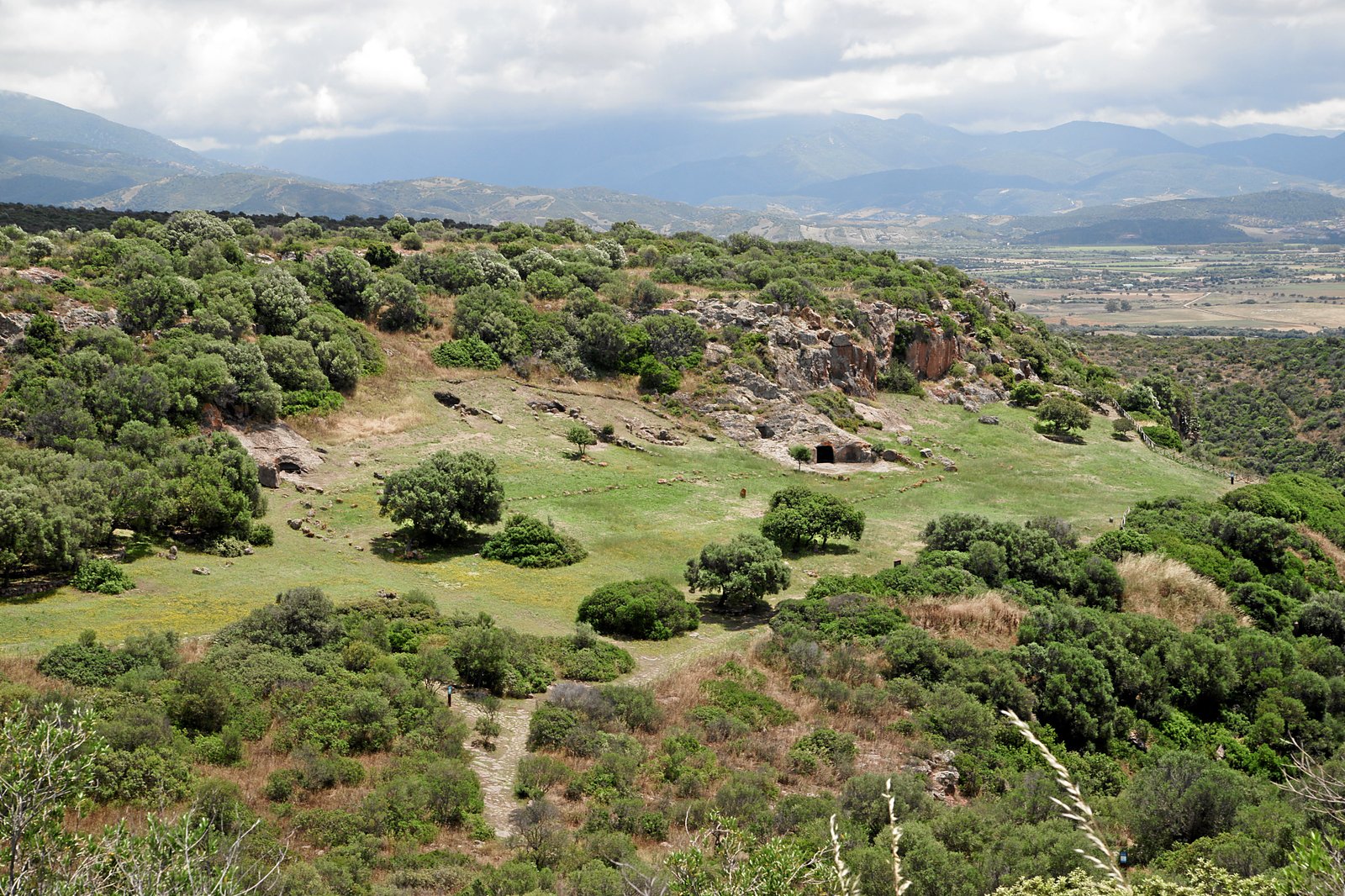
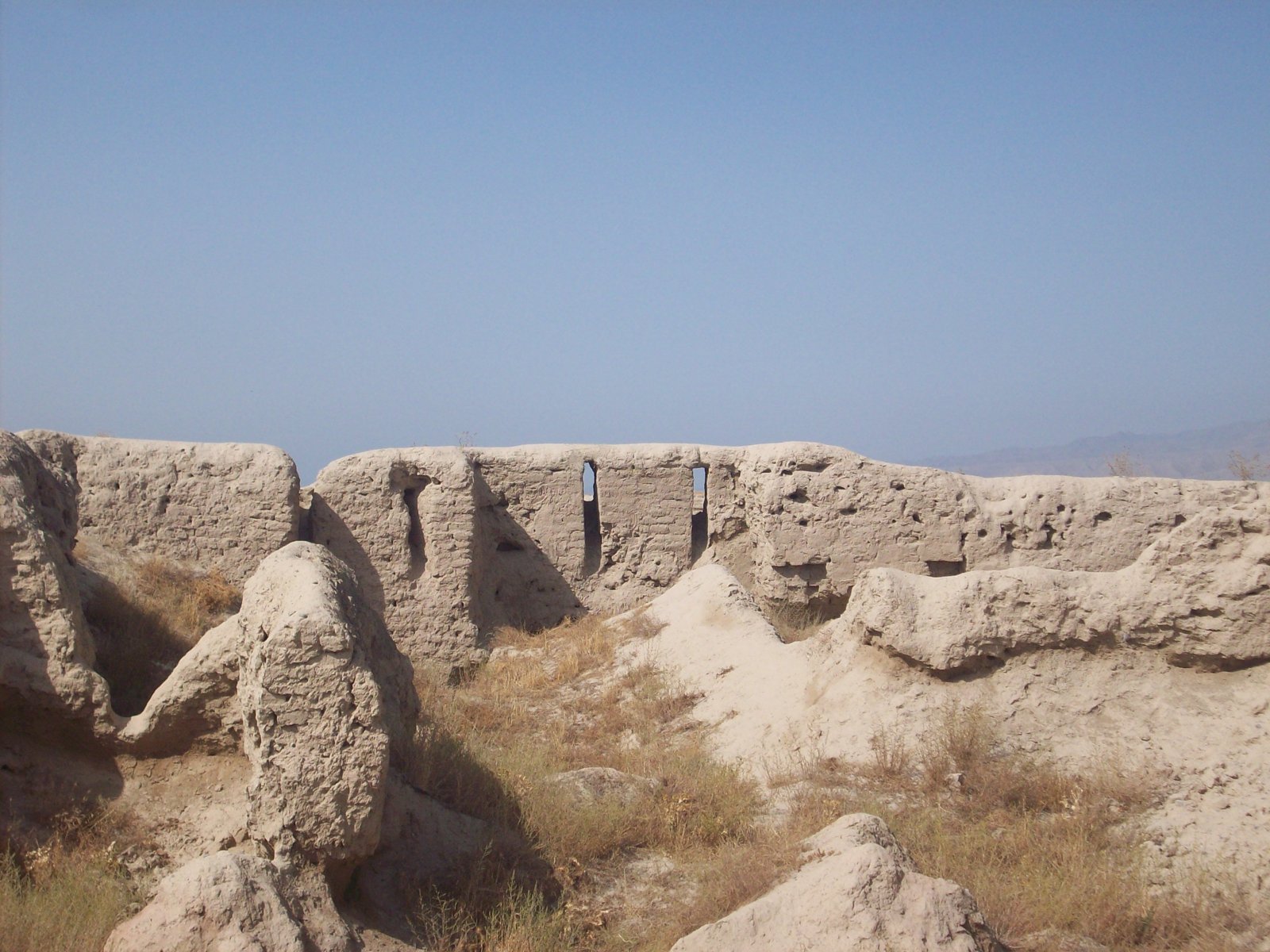
On the upper terraces above the Zarafshan river in modern Tajikistan lies a town that history simply stopped. Ancient Panjakent was a prosperous Sogdian city that grew from the 5th century AD into one of the liveliest centres of pre-Islamic Central Asia. Then, in 722 AD, an Arab army stormed it, its ruler fled, and the population drifted away. Unlike almost every other city in the region, Panjakent was never built over again. Its mud-brick walls, its temples and above all its astonishing wall paintings were left to be sealed by the dry Central Asian soil, earning the site its modern nickname: the Pompeii of the Silk Road.
Who were the Sogdians of Panjakent?
The Sogdians were an eastern Iranian people whose homeland, Sogdiana, clustered around oasis city-states in the Zarafshan valley. The name “Sughd” is old enough to appear among the lands of the Achaemenid Persian empire in the 6th century BC. By late antiquity the Sogdians had become the great middlemen of the Silk Road, their merchants and their language carrying goods and ideas between China, India, Persia and the steppe. The same trading network is visible in the Sogdian diaspora tombs of China, such as the Tomb of Wirkak and the Tomb of Kang Ye.
Panjakent sat about 90 kilometres east of Samarkand, the dominant Sogdian centre, and functioned as a small vassal town with its own ruling family and a thriving economy of landowners, traders and craftsmen. It was the easternmost town of Soghd, well placed to tax and service the caravans moving through the valley. That wealth, concentrated in a compact and self-confident community, is what paid for the painted houses that make the site famous today.
The city the excavators uncovered
Ancient Panjakent was never large, but it was densely and deliberately built. Archaeologists divide the surviving site into four parts: the walled town proper, covering roughly 13.5 hectares; a separate governor’s citadel of about 2.5 hectares on higher ground; the rabad, or surrounding suburb of country estates spreading across some 70 hectares; and a cemetery of Zoroastrian ossuary structures beyond the walls.
Within the town, diggers have traced eight streets, a market square, rows of shops and craft workshops, defensive works, and two Zoroastrian temples at the heart of the settlement. The houses were built of mud brick and timber, and the grander ones rose two storeys around courtyards, with reception halls whose walls were given over almost entirely to painting. Fire altars and small domestic shrines confirm that Zoroastrian practice ran through everyday life, even as the art reveals a far more cosmopolitan religious world.
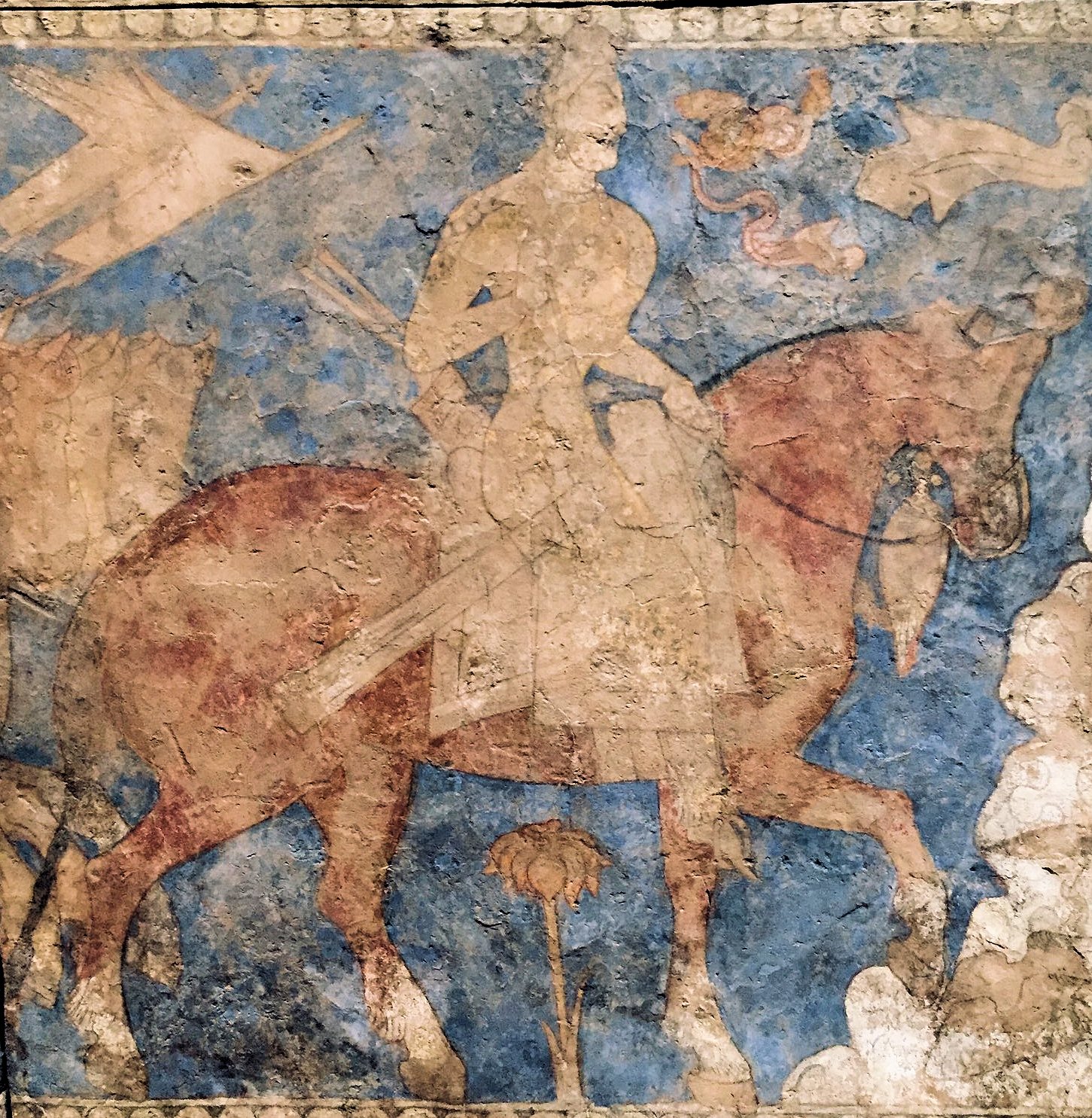
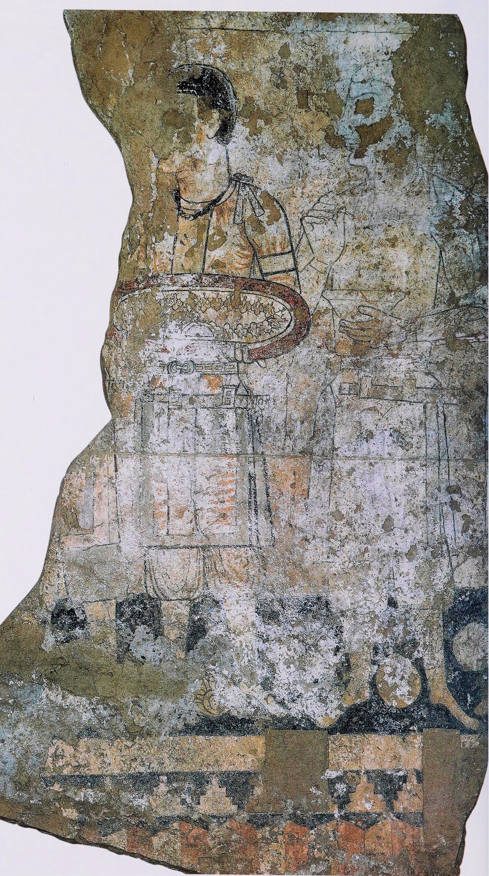
Frescoes of a lost world
Panjakent’s wall paintings are the reason the site matters far beyond Tajikistan. Produced from the 5th century until the catastrophe of 722, they survive in their hundreds and offer the richest visual record of Sogdian life anywhere. The painters worked in vivid mineral pigments, filling halls with banquets, processions, combats and gods.
A meeting point of Iranian, Indian and Mediterranean ideas
The subjects are strikingly eclectic. Iranian epic dominates: long narrative friezes illustrate the deeds of the hero Rostam, the cycle later gathered into the Persian Shahnameh. Alongside them appear the goddess Nana riding her lion, a four-armed Shiva clad in tiger skin reflecting the spread of Shaivism into Central Asia, and even a she-wolf suckling two infants that unmistakably echoes the Roman tale of Romulus and Remus. Scholars have also identified scenes drawn from Aesop’s fables. Today many of these murals are conserved in the Hermitage Museum in St Petersburg and the National Museum of Antiquities of Tajikistan in Dushanbe.
Divashtich, the Mount Mug archive and the fall of 722
The end of old Panjakent is documented with unusual precision, thanks to a remarkable archive. Its last independent ruler was Divashtich, who held the town from around 706. When Arab forces under the Umayyad governor pressed into the upper Zarafshan, Divashtich withdrew with his followers to a small castle on Mount Mug, east of the city. He was captured there in the late summer of 722 and executed soon afterwards.
In 1932 and 1933, documents found in the abandoned Mount Mug castle turned out to be his state archive: eighty-one Sogdian texts, one in Arabic, one in Turkic and several in Chinese, covering law, trade, diplomacy and the politics of a kingdom in its final crisis. The Arabic letter names “Diwasti,” tying the whole archive to a ruler already known from Muslim histories and fixing the date of Panjakent’s fall. For about fifty years the town struggled on under new administrators before its upper terraces were depopulated and its people relocated, leaving the old city to the soil.
From Soviet trenches to UNESCO status
The first sustained excavation of ancient Panjakent began in 1946, when the Sogdian-Tajik archaeological expedition was organised under the historian Aleksandr Yakubovsky. The dig later passed to Aleksandr Belenitsky and then to Boris Marshak, who directed the work from 1978 until his death at the site in 2006 — more than half a century of his life spent on these ruins. Marshak even stayed on through the Tajik civil war of the 1990s to keep the excavation and its conservation going.
This is worth stressing because popular accounts often credit Marshak with the very first digs of 1946; in fact he inherited a project Yakubovsky had launched. Their combined decades of patient work, season after season, are what reconstructed the street plan and rescued the paintings. In 2023 the site was inscribed on the UNESCO World Heritage List as part of the serial property “Silk Roads: the Zarafshan-Karakum Corridor,” recognising Panjakent’s place in the network that once linked half the ancient world. Just downstream lies the far older Neolithic settlement of Sarazm, inscribed by UNESCO in its own right.
Why does Panjakent still matter?
Because it was abandoned rather than rebuilt, Panjakent preserves a single, coherent moment of Sogdian civilisation instead of the jumbled layers most ancient cities leave behind. Its paintings let us watch a confident, trading, image-loving society that mixed Zoroastrian, Iranian, Indian and even Mediterranean ideas without apparent strain. The Mount Mug archive gives that society a documented political voice, and the long Soviet and Tajik excavations turned a buried hill into one of the best-understood towns of early medieval Central Asia. For more sites like it, browse our Ancient Civilizations archive. For anyone trying to picture the Silk Road as lived experience rather than a line on a map, the frozen town above the Zarafshan is as close as the evidence comes.
Neural Pathways is a collective of seasoned experts and researchers with a profound passion for unraveling the enigmas of ancient history and artifacts. With a wealth of combined experience spanning decades, Neural Pathways has established itself as a leading voice in the realm of archaeological exploration and interpretation.