Along a stretch of the Upper Indus around the town of Chilas, in the Diamer district of Gilgit-Baltistan in northern Pakistan, the cliffs and boulders are covered in tens of thousands of carvings. Scholars have called it an open-air museum: a record scratched into stone by hunters, merchants, pilgrims and conquerors from about 8,000 BCE onwards. These are the Diamer-Basha petroglyphs, one of the largest concentrations of rock art among the world’s most remarkable ancient historical places — and most of them are about to disappear beneath the reservoir of a new hydroelectric dam.

A rock gallery on the Upper Indus
The carvings are concentrated along the banks of the Indus where the river cuts through the Karakoram, clustered around old crossing points, camp sites and caravan halts near Chilas and the facing bank at Thalpan. For most of history the terrain protected them: the gorges were so hard to reach that few outsiders ever saw them. That changed only in the late 1970s, when the Karakoram Highway was pushed through the mountains and turned a near-impassable frontier into a road.
Access brought scholarship. From the 1980s a Pak-German Archaeological Mission systematically catalogued the boulders, and the sheer scale of the site became clear. Researchers documented on the order of 50,000 carvings and 5,000 inscriptions strung along the valley; one detailed survey recorded 37,116 petroglyphs and 3,618 inscriptions on 5,928 boulders across some 95 separate archaeological sites. Few rock-art landscapes in the world are so dense or so continuously used.
How old are the Diamer-Basha petroglyphs?
The oldest carvings date to around 8,000 BCE, in the transition from the last Ice Age, and the sequence runs unbroken up to the 16th century CE and the arrival of Islam in the region. That is roughly ten thousand years of people leaving marks on the same rocks. Because the engravings carry no organic material, they cannot be radiocarbon dated directly; archaeologists place them instead by style, by the scripts of accompanying inscriptions, and by the way the pecked surfaces have re-weathered over time.
What the carvings show
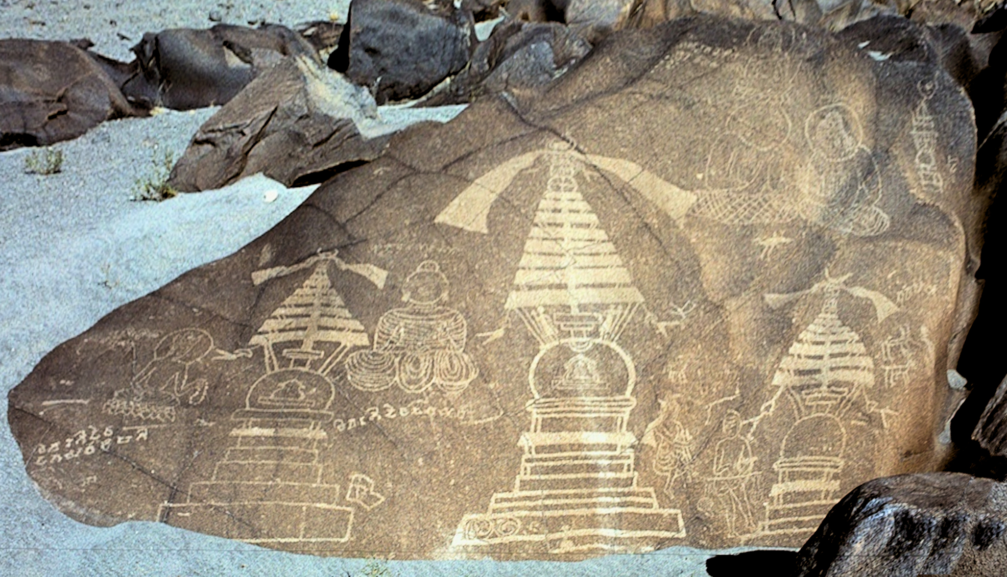
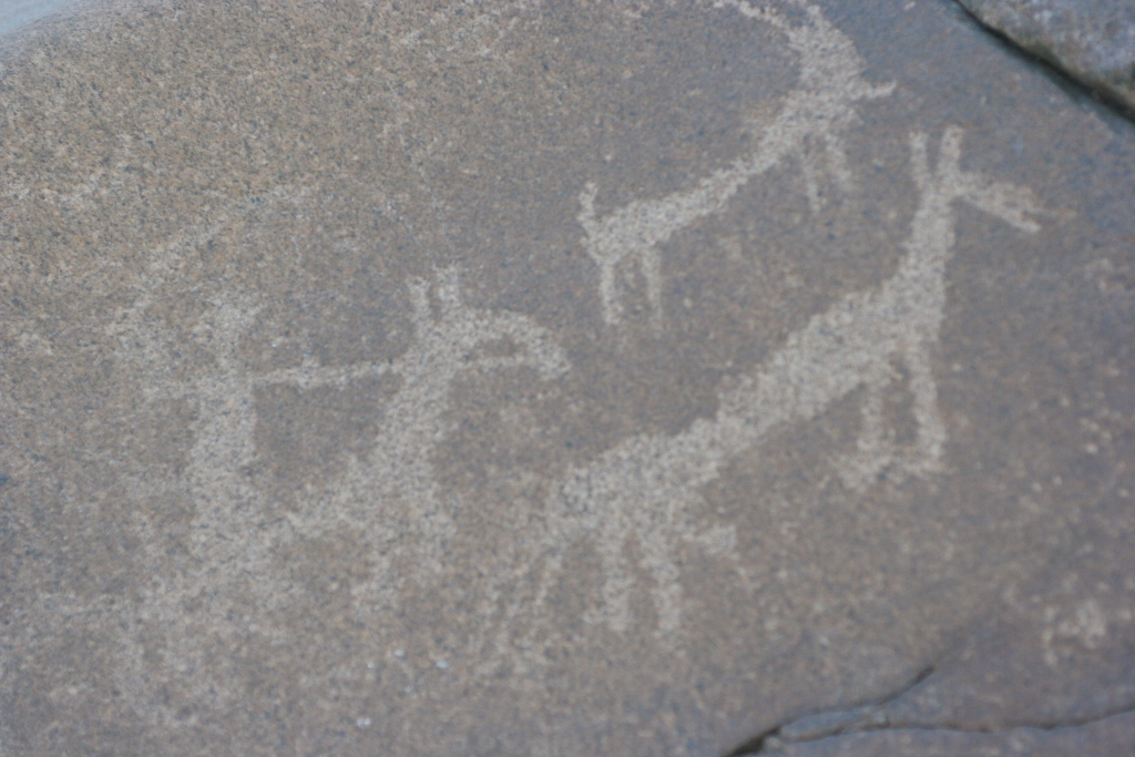
The most common motif is a single animal — above all the ibex, the wild mountain goat of the Karakoram — alongside hunting scenes and stiff, angular human figures that scholars nickname “triangular men.” From the first millennium CE the imagery turns overtly religious: images of the Buddha and finely rendered Buddhist stupas, one Chilas boulder bearing a stupa carved around 300 to 350 CE. The inscriptions are even more revealing, written in Brahmi, Sogdian, Tibetan, Chinese, Hebrew and the Bactrian script — the diary entries, in effect, of travellers from across Asia who wrote their names and prayers into the rock as they passed.
A crossroads of the Silk Road
The valley owed its traffic to geography. The route along the Upper Indus and its side valleys was a branch of the Silk Road, linking the oasis cities of Central Asia with the Buddhist heartland of Gandhara and the wider Indian subcontinent. Merchants, artisans and above all Buddhist pilgrims moved through the gorges, and many paused to carve. The dense clusters of stupas and Buddha figures record centuries in which this was a devotional as much as a commercial highway — a stone counterpart to the Sogdian trading world documented at sites such as the Panjakent excavations further north. In its variety of hands and scripts, the Chilas rock art rivals better-known galleries such as the Saimaluu Tash petroglyphs of the Tian Shan.
Why the Diamer-Bhasha Dam threatens them
The same river that drew the carvers is now being dammed. The Diamer-Bhasha Dam, under construction on the Indus under Pakistan’s Water and Power Development Authority (WAPDA), is a 272-metre-high structure whose eight-million-acre-foot reservoir is designed to generate 4,500 megawatts of electricity and irrigate 1.2 million acres of farmland. The project broke ground in 2020. When the reservoir fills, it will flood the very stretch of valley where the petroglyphs are densest: by official estimate around 35,000 carvings lie within the future lake. Cutting them free is not an option — the rock is igneous, deeply weathered and so fragile that removing a carving would destroy it.
Can the petroglyphs be saved?
Not in place, and not in full. WAPDA’s Cultural Heritage Management Plan concedes that the majority of the original carvings will be submerged, and concentrates instead on rescue by record. Some 5,000 of the most important petroglyphs — a selection made by Harald Hauptmann, the Heidelberg University archaeologist who led the Pak-German mission until his death in 2018 — are being digitised with 3D cameras so that full-scale replicas can be displayed in a planned museum. That museum is to be housed in the 19th-century Chilas Fort, a British-era building acquired for the purpose, with tourist trails and a rock-art garden intended to keep the heritage economically alive.
Engineers have looked at bolder rescues. One model is Baiheliang on China’s Yangtze, an inscribed ledge submerged by the Three Gorges Dam and now preserved under a water-filled glass dome that visitors descend to see; WAPDA has raised the possibility of a similar structure over the most significant Chilas carvings, and of protective chemical coatings for engravings left above the waterline. The site sits on no UNESCO World Heritage List, which would carry legal protection, though the World Monuments Fund has counted it among the world’s threatened places. As reporting by Dialogue Earth and the documentation of the Pak-German mission both stress, heritage of this kind is a non-renewable resource: once the water rises, what was not recorded is simply gone.
Sources and further reading
- World History Encyclopedia — Gandhara
- Wikipedia — Diamer-Bhasha Dam
- Wikipedia — Chilas
- Dawn — Wapda to digitise prehistoric rock carvings at Diamer Basha Dam site

Neural Pathways is a collective of seasoned experts and researchers with a profound passion for unraveling the enigmas of ancient history and artifacts. With a wealth of combined experience spanning decades, Neural Pathways has established itself as a leading voice in the realm of archaeological exploration and interpretation.