Summary:
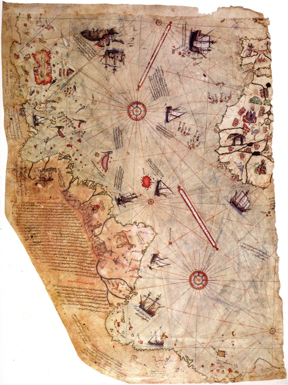
The Piri Reis map, named after its creator, Ottoman Admiral Piri Reis, is a fascinating artifact from the early 16th century. It’s known for its unique depiction of the world, particularly the Americas, during a time when cartographic knowledge was limited. The map, drawn on gazelle skin parchment, has sparked intrigue and debate among historians and scholars due to its remarkable accuracy and the mystery surrounding its creation.
Get your dose of History via Email

Historical Background of The Piri Reis map
The Piri Reis map was created in 1513, a time when the New World was still being explored. It’s believed that Piri Reis used a variety of sources, including maps from Columbus’s voyages, to compile his own map. Interestingly, this map only depicts half of the world, focusing on Europe, Africa, and the Americas. It’s said that the missing part of the map was either lost or never completed.
The map is unique for its time, showcasing an understanding of the world that was advanced for the early 16th century. The depiction of South America’s coastline, for instance, is remarkably accurate. The map also includes detailed drawings and notes about various regions, showing Piri Reis’s keen interest in geography and exploration.
Despite its historical significance, the map remained unknown for centuries. It was rediscovered in 1929 in the Topkapi Palace, Istanbul, during a clean-up of the palace library. Since then, it has been a subject of intense study and speculation.

Architectural Highlights/About the Artifact
The Map is drawn on gazelle skin parchment, measuring approximately 90 by 63 centimeters. It’s filled with intricate details, from finely drawn coastlines to annotations in Ottoman Turkish. The map’s colors, mainly blue and red, are still vibrant, a testament to the quality of the materials used.
One of the map’s striking features is its depiction of South America’s coastline, which is remarkably accurate for its time. The map also includes parts of North America and the Caribbean, with detailed depictions of islands, including Cuba and Hispaniola.
The map is also notable for its detailed drawings and annotations. Piri Reis included information about local cultures, flora and fauna, and even sea routes. These details provide a fascinating glimpse into the world as it was known in the early 16th century.

Theories and Interpretations of The Piri Reis map
The Map has sparked numerous theories and interpretations. Some scholars believe that the map’s accuracy suggests the use of advanced cartographic techniques, possibly inherited from ancient civilizations. Others argue that the map is evidence of early contact between the Old World and the Americas, predating Columbus’s voyages.
One of the most controversial theories involves the map’s depiction of Antarctica. Some claim that the landmass shown south of South America is, in fact, the Antarctic coast, free of ice. This theory, however, is widely disputed, as Antarctica was not discovered until 1820, and its ice-free state hasn’t been seen for millions of years.

Good to know/Additional Information about The Piri Reis map
Today, the Map is housed in the Topkapi Palace Museum in Istanbul. It’s considered a national treasure and is rarely displayed to the public to preserve its condition. However, reproductions of the map are widely available for study and appreciation.
The map continues to be a subject of research and debate. Its mysteries, such as the sources used by Piri Reis and the missing half of the map, keep scholars intrigued. Despite the debates, one thing is certain: the map is a remarkable artifact that offers a unique glimpse into our world’s history.
Conclusion and Sources
The Piri Reis map is a fascinating artifact that continues to captivate historians, geographers, and enthusiasts alike. Its intricate details, remarkable accuracy, and the mysteries surrounding its creation make it a significant piece of our world’s history.

For further reading and to validate the information presented in this article, the following sources are recommended:
Neural Pathways is a collective of seasoned experts and researchers with a profound passion for unraveling the enigmas of ancient history and artifacts. With a wealth of combined experience spanning decades, Neural Pathways has established itself as a leading voice in the realm of archaeological exploration and interpretation.