Gusir Höyük: An Overview
Gusir Höyük is a prehistoric settlement that will be inundated by the Ilısu Dam reservoir. The site will be covered by 20 meters of water upon the project’s completion. Discovered in 1989 during the Tigris-Euphrates Archaeological Reconnaissance Project, it was initially named Güzir Höyük.
While the exact beginnings of Gusir Höyük remain under investigation, radiocarbon dating places its primary activity during the Pre-Pottery Neolithic period, a remarkable timeframe between 8075 and 7600 BC. This establishes Gusir Höyük as one of the earliest known settlements in Anatolia, offering invaluable insights into human life during this pivotal era.
Discovery and Initial Studies
G. Algaze and his team discovered the site in 1989. They published their findings in 1991. Our team from the University of Istanbul began systematic rescue excavations in 2010. This was almost 20 years after the initial reconnaissance.

Location and Environmental Setting
The mound is located beside Gusir Lake, 40 km south of Siirt. It is 2 km west of Ormanardı Village in Eruh County. The site sits on the southern shore of Kavaközü Creek, a tributary of the Botan River. Gusir Lake is a sinkhole fed by Kavaközü Creek and nearby springs. The western side is covered with flatlands extending through the Botan River bed. The terrain rises steeply in the south before descending towards the Tigris River canyon.
Archaeological Context
The site covers an area approximately 150 meters in diameter. Its top is at 535 meters above mean sea level. The earliest settlement seems to be at the level of the present surface of Gusir Lake. Thus, the archaeological deposit should be 7 or 8 meters thick. Most of the archaeological material belongs to the Pre-Pottery Neolithic period. C14 dates from various layers cluster between 9975 and 9600 BP.
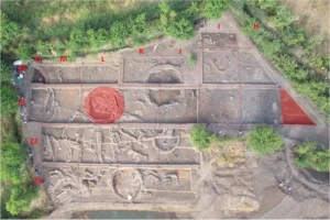
Excavation Findings
During the first excavation season in 2010, we worked on an area of 900 square meters. We set two trenches on the stepped terraces descending towards Gusir Lake. Another trench was set on the terrace above them. We identified at least four different periods in the excavated area.
Stratigraphy and Architectural Remains
Just below the surface soil, we encountered several buildings of various sizes. These buildings displayed circular or almost circular plans. The largest building is rectangular with rounded corners and an outer diameter of 10 meters. The walls are almost a meter thick and have two surfaces. Inside, a large stone-laid area made with river cobbles is evident. Some cobbles show traces of burning. A stone slab stands in the middle of the building. Its width is 80 cm, and its thickness is 20 cm. The upper part is missing, and the lower part is still to be excavated.

Additional Structures and Burials
We found two adjacent buildings in the south and southeast of the large building. These smaller buildings have thinner walls and a rectangular shape with rounded corners. We also recovered parts of at least five other buildings. These buildings display similar wall construction techniques. One building has a standing stone slab similar to the one in the large building. Highly burnt adobe remains indicate extensive use above the stone foundations. To the west of the large building, an open area possibly functioned as a courtyard. We recovered three simple inhumation burials from this area.
Chipped Stone Assemblages
Our work on the typology and technology of the chipped stone assemblages is ongoing. Flint dominates the assemblage, but obsidian is also present. Preliminary observations suggest the source to be Bingöl – Nemrut in Eastern Anatolia. Flint was evidently worked at the site. We found numerous flake and blade cores. The tool types include points, scrapers, perforators, and retouched blades and flakes. The presence of “Nemrik points” is significant as a chronological indicator.
Small Finds
The majority of the small finds consist of grinding stones and pierced stones. Basalt grinding-stones are particularly large and heavily worn. We recovered roughly shaped, pierced limestone artifacts of various sizes. Their functions are not clear. We also found roughly shaped limestone vessels, pestles shaped as animal heads, hand stones, mortars, and stone plugs. Bone awls are also numerous. A decorated stone found on the periphery of the excavation site bears similarity to Körtik Tepe decorated grooved stones.

Conclusion
Our first excavation campaign at Gusir Höyük exposed four architectural layers. The architectural remains in each layer differed significantly. Further study is needed to understand whether different building shapes co-existed in the same period.
Sources:
Academia.edu
Researchgate
Neural Pathways is a collective of seasoned experts and researchers with a profound passion for unraveling the enigmas of ancient history and artifacts. With a wealth of combined experience spanning decades, Neural Pathways has established itself as a leading voice in the realm of archaeological exploration and interpretation.